FUNDY ISSUES #11
Spring 1999
Whither the Waters?
Tidal and Riverine Restrictions in the Bay of Fundy
and the give and take between land and sea was rapid and substantial."
Taming Tides
A thousand years ago a Viking King, Canute, sat upon a throne on a Sussex beach as the rising water ignored his command to halt, and washed relentlessly about his ankles. It was a dramatic demonstration of the powerlessness of even a king, to command the sea and arrest the timeless ebb and flow of the tide. "Let all men know how empty and worthless is the power of kings", he proclaimed. Then, almost 600 years later, on Fundy’s fertile shores, less renowned individuals set about doing what Canute could not. Since then, they and their descendants have been all too successful in fending off tidal floods far mightier than those of the Sussex coast. This is the story of how they did it, but even more importantly about how they also unwittingly strained and ruptured the many, intricate ecological bonds linking the sea and the land. However, as the legend of Canute affirms, there once was a time when seas flowed freely upon shores everywhere, and thus it is with the unfettered sea that we begin.Liquid links
The shoreline, where sloping land plunges beneath lapping sea, is not a barrier between ecological solitudes, but rather a zone of lively interchange, uniting distinct but closely linked natural realms. Water is the principal currency in this brisk ecological commerce. Vast amounts, intricately channeled from trickles, to rivulets, to streams and finally to rivers, drains from the land’s "watershed" into the coastal sea. In the other direction, from the sea, substantial quantities flow over low lying coastal "wetlands", or surge far inland along river channels, with each rising tide. This watery bond binds the coastal sea and its terrestrial watershed together, mostly to their mutual benefit, but occasionally to their detriment. Although the two-way exchange of water is itself important, it is even more ecologically significant because of what the water bears within it: salts, sediment particles, organic detritus (decomposing fragments of plants and animals), dissolved nutrients and living plants and animals are moved to and fro relentlessly. Nowadays, noxious or toxic wastes from household, farm and factory are sometimes involved in the transaction, but that is another story told in "Fundy Issue # 8: Fundy’s Watery Wastes? – Pollution in the Bay of Fundy".It is the ceaseless traffic in natural materials between land and sea that makes many coastal areas rich in the variety of animal and plant species (biodiversity), as well as in their individual abundance and productivity. Although such tidal commerce occurs on all coasts, it is of particular significance in the Bay of Fundy. For here, the rise of the tide could submerge a four-story building, and the shore so gently sloping that in places the sea advances many kilometres over thousands of hectares of "intertidal" wetlands. Scientists apply the term "macrotidal" (large tide) to the Fundy marine environment. Here the scope for the processes of ecological give and take is immensely magnified. Fundy’s ecosystems are moulded and sustained by these great tides and the surging rivers. Any check on the flows of water in either direction impedes the transport of the materials carried and diminishes their roles in ecological processes. But, what exactly are these natural roles?
The amount of salt dissolved in water has important physical, chemical and biological consequences. Salt-laden seawater mixes with freshwater flowing off the land to form brackish water; saltier than freshwater, less salty than seawater, forming a continuous gradient between these extremes. Fundy’s powerful tides force seawater far upriver (sometimes dramatically as a tidal bore) and extend the marine influence well inland. The freshening influence of larger rivers also extends seaward from the mouth. Semi-enclosed coastal areas where freshwater mingles copiously with seawater are "estuaries". Their brackishness depends on the amounts of seawater and freshwater that have mixed, and in a typical estuary this can vary greatly over short distances, both vertically and horizontally. At a given place it may also fluctuate with the stage of the tide or the season of the year. Aquatic animals and plants are usually rather particular about the salt content of their liquid habitat. Marine ones normally live only in seawater and freshwater ones only in water with imperceptible salt content. However there are many species that tolerate and even prefer brackish water. Their occurrence in different parts of the estuary is largely conditional on the presence of water within a particular range of saltiness.
The brackishness in various areas of an estuary not only determines which plants and animals live there, but also plays a major role in the fate of particulate matter (detritus and sediment) carried in by rivers. As a river flows towards the sea it widens, deepens and slows so that the heavier particles sink to the bottom. Less obvious is the fact that as the fresh water mixes with salt water, its burden of fine organic and inorganic particles gradually clumps ("flocculation") and begins to settle to the bottom of the estuary. This is akin to the coagulation observed when egg-white seeps from a cracked shell into salty water. Flocculation mostly occurs over a narrow range of salinity and thus typically the finer, organic-rich particles settle and accumulate in well-defined areas in the estuary. Anything that changes the pattern of distribution of brackish water thus changes the zone where flocculation and settling tend to occur. In addition, if river flow is reduced, seawater moves further upstream before depositing its load of sediments, sometimes forming mudflats or sandbars where none existed before. Thus the nature and distribution of sediments on the seafloor in estuaries is complex and sensitive to water flows in both directions. Changes in the character of bottom sediments invariably alters the abundance and distribution of bottom-dwelling organisms, as most are rather finicky about their substrate.
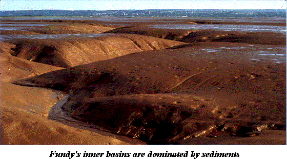 |
Flowing waters have had even more profound and widespread impacts on the sediments of the Bay of Fundy. Its inner basins are overwhelmingly dominated by sediments. Long before man dwelt upon them, the shores were being massaged and moulded by the ceaseless, rhythmic press of the sea. The surrounding land is largely comprised of soft, red sandstones and shales that are easily eroded and washed away by pounding waves and scouring rivers. The vigorous tidal mixing keeps the tiny fragments suspended and mobile. Twice daily muddy-red, silt-laden water sweeps over the low-lying shores, and twice daily withdraws. With each advance the sea yields some of its burden and with each retreat it takes. This constant give and take of material has over the centuries built up the thick mudflats and salt marshes that adorn much of Fundy’s shoreline. However, these sediment-based habitats are not as fixed and timeless as they seem at first glance. Change either the rate of erosion or deposition of sediments and a mudflat or salt marsh will shrink, grow or gradually move in response. Water flow (current) is the driving force behind such sediment transport. Current direction determines where sediments move and current speed determines how much is carried and whether bottom sediments are picked up or deposited. Currents are temperamental, responsive to many influences, and tend to vary greatly over time. Thus salt marshes and mudflats are sometimes short-lived on the geological time-scale because they mirror the changing currents. In addition, as sea levels rise or fall (also only detectable on the scale of geological time, though climate change may be accelerating the process) the fringing salt marshes and mud flats migrate shoreward or seaward in response. Tampering with current flows by humans further complicates and often accelerates such ongoing changes in the marine coastal landscape.
Salt marshes play yet another vital role in the interchange of material between land and sea. The sea deposits thin layers of inorganic, nutrient-rich sediments upon the marshes at each tide. The densely packed stalks of the marsh grasses slow the currents and serve as sediment traps. The plants then absorb nutrients from the accumulating sediments and grow lush and luxuriant. Throughout the year, but particularly in fall and winter, dead and dying grasses fragment and begin to decay. With each tide, large amounts of this nutritious, organic detritus is swept off the marsh and into the sea, to be consumed by a wide array of marine organisms such as bacteria, worms and shrimp-like crustaceans. Scientists characterise this rapid uptake of nutrients, and the subsequent release of large amounts of organic matter into the sea, as a "nutrient pump" that is responsible for much of the marine productivity of the upper Bay.
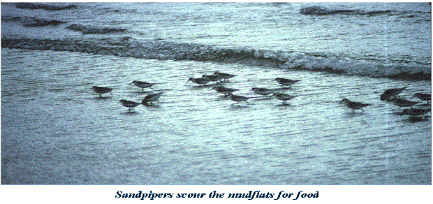 |
Animals too are carried along by the moving waters, or use them as watery highways for their wanderings. As the rising sea washes over mudflats and salt meadows, hordes of fish that have waited expectantly just beyond the surf scurry in over the newly-submerged land in search of a meal. That this muddy zone is a well-stocked larder is evident from the fact that, just on the opposite side of the tide line, large flocks of hungry shorebirds impatiently mill about awaiting their turn to dine at the same table once the water recedes. The main course at both intertidal banquets features the myriad, small organisms, such as worms, molluscs and shrimp-like crustaceans, that dwell within the sticky mud. Their continued abundance is also dependent on the ebb and flow of the water, not only to bring fine organic particles for them to eat, but also to disperse their tiny eggs or young. For many fish, the sea and the watercourses branching from it are the pathways of a more extensive migration between feeding and breeding grounds. Some, such as salmon and gaspereau, lay their eggs in freshwater streams but spend most of their life at sea ("anadromous" fish). Others such as eels lay their eggs at sea but spend much of their adult life in freshwater ("catadromous" fish). The survival of all these so-called "anacats" is dependent on their free passage between these critical habitats at the appropriate time in their life.
Curbing currents
But the sea no longer freely moves upon the shores and into the rivers of the Bay of Fundy. In the course of almost 400 years, European settlers have changed the coastal landscape in ways that Canute could scarcely have imagined. Their industrious activity and constructions have increasingly impeded the free movement of water and its natural cargo; imperceptibly at first, but with greater scope in each passing century. Forestry, agriculture and human settlements have all profoundly altered the nature and texture of much of the land surface and changed the natural patterns of freshwater runoff of entire watersheds. But it is coastal structures, particularly barriers such as dikes, dams, causeways, bridges, wharves, breakwaters and landfills, and their effects on water movement, that chiefly concern us here.The most characteristic and historical of the man-made structures in the region are the great earthen dikes lining the shore in many places. Before European settlement, the tides of Fundy flowed unhindered over the surrounding salt marshes and the give and take between land and sea was rapid and substantial. Within a few decades of their arrival in the early 1600’s, French (later Acadian) farmers began diking, draining and converting to agricultural production great tracts of salt marsh meadows, an activity that expanded during the subsequent two centuries by both Acadians and later settlers. It is estimated that eventually between 75% and 90% of the original salt marsh was wrested from the sea in this manner. Today, virtually all of this "reclaimed" land remains shut off from the sea, with little, if any, mutually beneficial exchange of sediment, organic matter and nutrients.
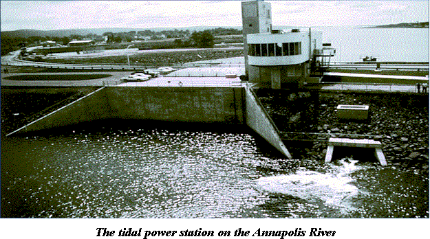 |
However, from the moment of their construction, the earthen dikes have been subjected to a relentless onslaught by waves and currents. Thus, their continual maintenance has been a necessary, labour intensive and expensive undertaking. By the 1950’s it was decided that large stone barrages placed across the mouths of tidal rivers would better, and more cheaply, protect much of the reclaimed land. This would reduce tidal flooding, regulate water levels and end costly repairs to upstream dikes. In many places the barrage could also be used for highway and railway crossings, and the one across the Annapolis River now supports a prototype tidal-power generating station constructed in 1986. Most of the large rivers of Fundy were blocked in this manner within two decades. But these certainly weren’t the first dams in the region, simply the largest and latest. Economic development in the area, almost from the outset, depended on the availability of the cheap, renewable waterpower provided by rivers and streams or by the surging tides in narrow channels. Thus, over the centuries most smaller rivers were dammed to create a head of water for generating power. Initially, this involved wooden waterwheels producing mechanical energy to power millstones, saws and other machinery located nearby. In this century steel turbines power large generators that produce electrical energy that can be transported far afield. All these barrages and dams, large and small, have greatly interfered with the natural flow of freshwater into coastal wetlands and the sea and, if located near the mouths of rivers, with the twice-daily tidal incursions of seawater into estuaries. A small, knowledgeable group of Environment Canada scientists and managers recently listed the major Fundy Rivers and made a preliminary assessment of the number, nature and effects of barriers and restrictions on them (see Further Reading). Of the 44 large to medium-sized rivers flowing into the Bay (18 in New Brunswick and 26 in Nova Scotia), fifty-seven percent have large dams or causeways that block or severely restrict river flow, and most others have some form of tidal restrictions.
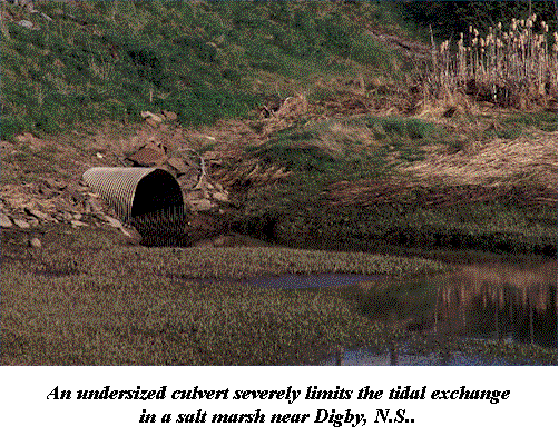
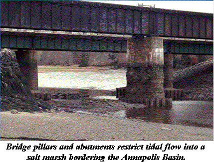
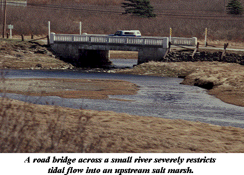
Even more insidious and pervasive than barrage construction has been the gradual spread of intricate networks of highways and railroads throughout the region. The construction of raised roadbeds across salt marshes and other low-lying areas blocks or diverts the natural flow of surface waters. Where roads cross rivers and streams, bridges or culverts are typically installed. Bridge approaches, abutments and support pillars constrict the river, hamper the passage of water, modify current patterns and alter flow rates. Culverts are often too small and thus greatly restrict water flows. Poorly designed culverts also greatly limit fish passage. From a fisheries perspective, the cumulative effect of inadequate culverts is substantial for both anadromous and freshwater migratory species. One of few such studies revealed that in New Hampshire, tidal flow was greatly impeded in one quarter of the state’s coastal marsh area, mostly because of undersized culverts. There, as here, transportation needs and engineering considerations largely determined where culverts and bridges were placed, designed and built, with little if any consideration given to possible ecological effects.
 |
Wharves, groins, jetties, breakwaters and other such structures that protrude into rivers, estuaries and coastal waters, although allowing the passage of water, can greatly alter the directions and velocities of currents. Given that Fundy’s sediment-based habitats are highly sensitive to shifts in currents, it is perhaps not surprising that such artificial protrusions can have major ecological consequences. Studies carried out in New England, California and elsewhere, of efforts to protect eroding beaches have shown that structures protruding from the shore interfere with the natural movements of sediments along the shore. Quantities of sediments are deposited just upstream of the structure, while large tracts of coast are eroded away for a considerable distance downstream. Most such structures have been designed and located solely on the basis of engineering and economic considerations, with the ecological consequences totally forgotten. Wharves and breakwaters have been built throughout the Fundy region for hundreds of years. Many have long since been washed away by the sea. Others are broken and no longer used, but their massive rock and timber skeletons still impede coastal and estuarine currents. On open coasts such structures probably have little ecological impact. But most of them tend to be located in rivers, embayments and estuaries because it is there that people have settled in large numbers. The ecological effects of many such structures jutting out from both banks into an already constricted estuary are undoubtedly significant. However, most such structures have been in place for decades to centuries, and we have no idea what the habitat might have been prior to their construction, or what it would revert to if they were removed.
In many places the dumping of large amounts of rock and soil has filled in areas of salt marshes or intertidal flats. This has typically been done to provide additional dry, useable land (often urban, e.g. Truro, Amherst) or to protect existing land from erosion by the sea. Such indiscriminate filling not only directly destroys salt marsh by burying it, it also affects the patterns of water flow over adjacent areas of marsh, possibly contributing to their erosion and loss. In much of New England, where the public is increasingly recognising the ecological role and value of salt marshes, such direct assaults are virtually banned or tightly regulated and monitored. In sharp contrast, a report commissioned by the Commission for Environmental Co-operation (see Further Reading) critically notes that around the Fundy coast it is not uncommon to see home-made signs proclaiming "fill wanted" posted on salt-marsh areas. There appears to be little official attempt made to regulate or even record such marsh destruction. A single, small-scale marsh filling may have only minor, barely perceptible local impacts. But taken together over the years, numerous such assaults in many different places undoubtedly result in the cumulative loss of a significant proportion of the remnant salt marsh area. And the resulting changes in water flow may affect even larger areas of habitat.
 |
We do not know just how widespread the environmental effects of all these coastal structures and activities are in the Fundy region, because no one has yet identified, counted and mapped them all in a comprehensive and consistent way. Neither has anyone comprehensively tallied the areas of remnant salt marsh, mudflat and other estuarine and coastal habitats that are degraded or threatened by such structures. Observations of a few large structures, such as the controversial causeway on the Petitcodiac, show that there are major environmental effects, and it is very likely that these are more widespread and destructive than we think. In their preliminary review of barriers on Fundy rivers, Peter Wells and his Environment Canada colleagues concluded that the real scope of the problem needs to be ascertained quickly so that critical remedial action can be undertaken. Thus, they recommend the development of an inventory of all such barriers and tidal restrictions, the mapping and evaluation of all remaining salt marshes, studies on the effects of barriers on tidal exchanges and estuarine ecosystems, and an examination of the feasibility and benefits of restoring tidal flow in selected rivers. Several such initiatives are well advanced in the southern Gulf of Maine, where population densities are higher and the value of remaining coastal wetlands is more generally recognised and appreciated. Fortunately, the tide of public opinion may also be slowly turning, around the shores of Fundy. A recent workshop on "Tidal Barriers in the Inner Bay of Fundy" and the ongoing efforts to enhance tidal exchange in the Petitcodiac River (see below) are welcome examples of promising steps in the right direction.
Harming habitats
All these barriers hinder the natural movements of both water and the varied dissolved and suspended material that it transports. Some of them block flows completely, while others permit some water passage, but alter flow characteristics, such as timing, velocity, volume or direction. These changes in turn can influence the structure and functioning of nearby ecosystems, with impacts ranging from near catastrophic (such as on the Petitcodiac River) to virtually negligible. It has proven very difficult to predict the short-term and long-term potential ecological effects of a particular barrier. Even years after installation, it is often not possible to determine just how much of the ecological degradation observed can be blamed on the barrier itself. Typically, too many other natural changes and human activities have also occurred in the region and largely obscured any "smoking gun" that might exist. Often, it is far easier to shift much of the blame to "global warming", "sea-level rise", "pollutants" or some other such convenient environmental scapegoat. In spite of this, we can make a good circumstantial, or weight-of-evidence, case about the adverse effects of barriers in general on the transport of waterborne materials and about the nature of the ecological degradation that results.The presence of barriers on rivers, estuaries and coasts impedes the movement of the water itself. Currents may be eliminated, or their strength and direction greatly altered. This can result in significant changes in the natural patterns of water circulation and mixing in estuaries and coastal waters. Water movement is essential to many ecological processes and changes can have profound effects on biological communities, modifying both water column and seafloor habitats. Barrages across estuaries reduce or eliminate normal tidal fluctuations in water levels in the lower reaches of the river, greatly altering water mixing, stream-bank erosion, the width of the intertidal zone and a host of other ecological processes and properties. In some rivers, such as the Petitcodiac, the barrage has virtually eliminated the great tidal bore that once surged far up the river to the delight of hordes of tourists, and expunged the positive marine influences along many miles of river.
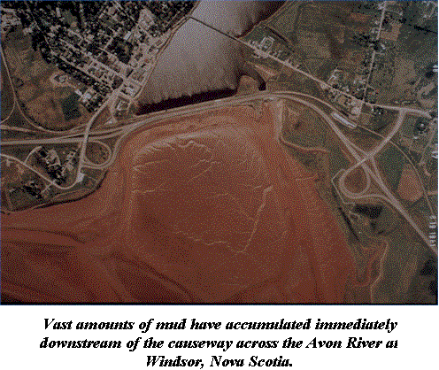
The potential effects of barrages on the transport of sediment and its distribution in the upper Bay of Fundy are described more fully in Fundy Issues number 3, "Sandpipers and Sediments: Shorebirds in the Bay of Fundy", and number 4, "Dykes, Dams and Dynamos: The Impacts of Coastal structures". These recount worrisome changes in sediment composition that seem to be taking place on some mudflats; although it is not yet clear what the causes are, what the ecological implications might be or how widespread the phenomenon is. There is a lingering suspicion that damming of most of Fundy’s large rivers during the 1950s and 60s may be implicated and that the long-delayed effects are only now becoming noticeable. A vivid example of the dramatic impact of barrages on sediment distribution can be readily seen from the causeway across the Avon River at Windsor, Nova Scotia. In the 30 years since construction of this barrier, a vast expanse of thick brown mudflat has almost completely filled in the river below it. Spreading grasses and other plants are now slowly transforming this into a new salt marsh. The barrier may also be responsible for accumulations of bottom sediments near Hantsport, more than 8 kilometres downstream. It is possible that there are also subtle effects on mudflats and other benthic habitats over even broader expanses of Minas Basin, but these are notoriously difficult to demonstrate convincingly. Any such disturbances of sediment dynamics by barriers are of particular concern, because fine sediments and mudflats are literally the foundation of the entire ecosystem in the upper Bay of Fundy. Water flow shapes the sediments and the sediments shape the ecosystem; the link is irrefutable and very, very vulnerable.
 |
As we have seen, rivers, estuaries and salt marshes are major exporters of dissolved nutrients and organic detritus to coastal marine ecosystems. Barriers that interfere with this export may substantially reduce the productivity of nearshore waters. In the Bay of Fundy, the extensive, historical diking has probably had the largest such impact. It is estimated that between 10 and 20% of the salt marsh present at the time of European colonisation now remains. We can only guess at how much more diverse and productive these coastal waters were when the marshes were six times as large and yielding correspondingly greater quantities of detritus and nutrients. The huge agricultural production on the "reclaimed" marshes over the past three and a half centuries has largely been achieved at the expense of comparable levels of marine production. Other tidal restrictions, such as culverts used to drain remaining marsh areas, tend to trap marine organic detritus and impede the normal export of marsh detritus into the sea. As a result some of these remnant marsh areas may have become net consumers of organic matter rather than productive suppliers of it.
These changes in water flow, salt concentration, sediment transport, and nutrient and organic matter exchange all have important consequences for the well-being of animals and plants living in estuaries and nearby coastal waters. Many of these biological consequences are indirect, complex, poorly understood and generally impossible to predict. Most are difficult to detect and measure, yet they may be of critical importance to the integrity of estuarine and coastal food webs, and also in the long-term, adversely affect both inshore and offshore commercial fish stocks. Anything that increases or decreases for extended periods the proportions of freshwater or saltwater entering the estuary inevitably changes the distribution of animals and plants in the water, on the seafloor and in the surrounding tidally influenced wetlands. The full range of potential biological consequences is far too great to be dealt with here. Ominously, we are probably oblivious to a wide range of other vital ecological relationships that are also dependent on unfettered tidal and river flows.
Two illustrative examples of ecological effects of barriers that are direct and readily demonstrable, include their impacts on salt marsh vegetation and on the migratory movements of anadromous fish. Plants inhabiting wetlands that fringe many Fundy estuaries are sensitive to changes in the salt content of the water saturating the soil. In most salt marshes there is a dynamic balance between an inflow of freshwater from the land and a periodic influx of saltwater from seaward. The distribution of the various species of marsh plants reflects the salinity gradient that is thus set up in the saturated soil. Very salt-tolerant species such as cord grass, Spartina spp., dominate in areas that are frequently inundated by seawater. Species that do not tolerate salt, such as cattails, Typha latifolia, extend out from the margin of the marsh wherever there is a freshwater influx. Other species range themselves across the marsh according to their preferred intermediate salinities Any barriers that alter either the volume of freshwater runoff or the extent of seawater incursions will change the pattern of salinity in the soil and thus the relative distribution of the different types of plants. In the most extreme case, such as when the marsh is diked, drained and completely cut off from the sea, the change in vegetation is dramatic. Freshwater from surrounding land flushes out the salt from the soil and is drained away, leaving relatively dry salt-free land. Salt-tolerant marsh plants are supplanted by terrestrial, salt-intolerant species, or by horticultural varieties in areas used for agricultural crops. Such areas are no longer salt marshes and perform none of their important ecological functions. In less extreme cases, restricting structures may permit some intrusion of seawater into a remnant salt marsh, but greatly reduce its volume and rate of flow. As a result, the freshwater runoff at the fringes expands its area of influence into the marsh and less salt tolerant or even freshwater species are able to gain a foothold in new areas. There is growing concern that several species of extremely invasive plants are exploiting these changing salinity patterns and rapidly overrunning salt marshes all around the Gulf of Maine. The most worrisome in northern areas of the Gulf are the common reed grass, Phragmites australis, and Purple Loosestrife, Lythrus salicaria. These invaders readily displace native plants, producing almost single species stands over large areas of marsh. There is convincing evidence that these invasions are a direct result of the proliferation of tidal restrictions in many coastal areas. A study carried out in coastal Connecticut clearly showed that areas with significant tidal restrictions had been transformed from typical Spartina marshes to ones dominated by Phragmites. A lowering of the marsh water table and a reduction in salinity in soil water caused this change. Such altered marshes are regarded as ecologically "degraded" and are thought to be much less productive in terms of their contribution to estuarine food webs, and are also much less suitable as habitat for waterfowl and wildlife.
 |
Dams and other barriers across rivers or estuaries inevitably block the passage of fish, particularly those species that migrate annually between marine and freshwater habitats. Many "anadromous" species, that spend much of their life at sea but return to rivers to spawn, historically migrated in large numbers into rivers around the Gulf of Maine. These huge seasonal "runs" supported important commercial and recreational fisheries for hundreds of years. However, most of the historic runs of Atlantic salmon, shad, gaspereau, sea-run brook trout, smelt and striped bass were extirpated many decades or more ago, a result of impassable dams and other barriers across rivers, water pollution, and heavy recreational and commercial fishing. There is also a large upstream transport of organic matter in the form of anadromous fish. Large numbers of these fish (many tons in some rivers) die of natural causes during spawning, resulting in substantial nutrient release in the rivers. Barriers and restrictions greatly reduce this input. Over the years, some attempts were made to allow fish passage by constructing "fishways" over or around the structures. However, most such structures are outdated, often poorly designed and maintained, and thus largely ineffective. The United States Fish and Wildlife Service estimates that in New England over 90% of former stream habitats are now inaccessible to migrating fish. While a comparable estimate is not available for Fundy’s rivers, the recent Environment Canada report notes that very few of the rivers flowing into the Bay of Fundy have adequate fishways around dams and other blocking structures.
Large structures such as causeways often have dramatic, readily observable impacts on habitats and organisms. As a result, such major undertakings are increasingly being subject to regulation and some degree of environmental impact assessment. Increasingly, ways of minimising some of the more damaging environmental effects are being explored. However, there are far more small-scale developments, such as culvert installation and marsh infilling, that have small, subtle, indirect effects on tidal exchange; they may only slightly alter the volume or the timing of water flows and cause barely perceptible changes in the local ecosystem. Such small-scale developments are mostly poorly regulated, unrecorded and undertaken with little concern for possible effects on the ecosystem. Any existing regulations are typically unheeded. Because the environmental impacts associated with each single development are seemingly insignificant, we are often lulled into a false sense of complacency. However, even minor, often indirect effects have an insidious way of accumulating and reinforcing one another as more and more developments, both large and small, are pushed forward. These are what worried ecologists call "cumulative" and "synergistic" effects; the ecological equivalent of "death by a thousand cuts". In the context of barriers, cumulative effects are the sum of changes resulting from all the structures in a coastal region. Synergistic effects are even more insidious, because the individual developments can reinforce one another so that the final environmental impact is much greater than if the separate effects are simply added together. Both are particularly menacing, because the ecological threat often only manifests itself when it is almost too late to do anything about it.
Winning back wetlands
In recent decades there has been a growing awareness throughout the communities of the Gulf of Maine of the many important ecological roles that coastal wetlands play as wildlife habitat and in sustaining the rich productivity of our marine waters. There is now also a better understanding of how important the land-sea water exchanges are to the continued existence and ecological functioning of these wetlands. As a result, there has been mounting alarm about the huge areas of coastal wetlands that have already been lost, as well as about the continuing loss as a result of ongoing human activities. We have also learned a great deal about how some of these activities adversely affect water flows and cause undesirable ecological changes. This has led to growing efforts to halt developments that would impede these water exchanges, or at least modify them so that their ecological impacts are reduced. The emphasis is now on protecting the natural hydrologic processes and the wetlands that remain. Equally important, are efforts to actually restore some of the original water exchanges that have long been blocked or severely reduced, and by so doing revive some of the wetland habitats and reactivate their critical ecological functions. Such efforts to reverse past ecological degradation are termed "remediation" by those involved, and are slowly gaining momentum. However, some ecologists and conservationists are now concerned that there has been little effort to "monitor" what happens to the degraded environment after "remediation" is carried out. They argue that careful study of the way in which ecosystems change following such projects will help to find the most effective and economical ways of inducing desirable changes, and of ensuring that the changes that occur are the ones anticipated. We could learn a great deal from such "monitoring" All too often though, money is provided for a remediation project, the project is undertaken and that is the end of it. It is simply assumed that the project had the desired results. We need to follow-up such projects in order to test our assumptions and our predictions so that we can progressively improve our ability to restore habitats and ecological processes. Such concerns about monitoring are being heeded in one of the more ambitious tidal barrier remediation efforts now underway in the Fundy region.Passions on the Petitcodiac
Recent attempts to restore tidal flow to the Petitcodiac River by opening tide gates in a causeway near Moncton, New Brunswick, clearly show that rewriting ecological history is no simple matter. Social, economic, political and ecological perspectives are all contributing factors in the complex equation to be resolved. The saga began in 1967-68, when a kilometre-long rock-filled causeway with 5 large tide gates was thrown across the Petitcodiac River. The causeway, by controlling water levels upstream, protects over 1300 hectares of farmland from flooding, and also serves as a highway link between Moncton and Riverview. Almost as an afterthought, a largely ineffective fishway was installed to allow the passage of migrating fish. Some of the changes resulting from this river blockage have been dramatic and readily noticeable. These include the accumulation of huge volumes of mud immediately below the structure, creation of a large headpond above the structure, virtual elimination of the popular tidal bore, and loss of most anadromous fish stocks in the river as well as of the once lucrative shad fishery far down the estuary. There have undoubtedly been a host of other impacts, less dramatically apparent and rather more difficult to demonstrate unequivocally. However, these subtler effects may be of equal or even greater ecological importance in the long-term and impact a far wider area. These include alterations in nutrient transport into coastal waters, alterations in sediment distributions well out into Shepody Bay, and changes in distribution and abundance of benthic animals in the estuary and even further afield. As the public has become increasingly aware of the environmental consequences of this causeway, there have been rising calls for the restoration of at least some degree of tidal flow in the river. Between 1988 and 1990, gates were left open for short periods, primarily to allow movements of migrating fish, mostly salmon smolt that had been released into the river in a last-ditch effort to save the stock. These temporary openings restored the tidal bore briefly and allowed a variety of fish species to reenter the river and estuary. However, these experiments were curtailed in 1990, largely because of the vociferous objections of homeowners who had built expensive waterfront homes around scenic "Lake Petitcodiac", and others who value the recreational opportunities offered by the headpond. They were worried about upstream movements of sediments filling the headpond, as well as by the recurring large expanses of mud that fronted their properties. The situation simmered for a few years as both sides debated and lobbied passionately on the issue. In 1996 Alyre Chiasson, a biologist at the Universit� de Moncton proposed that another experiment be carried out to answer some of the outstanding questions. This would involve a partial opening of the gates for a period and a co-ordinated research program to monitor changes in erosion, sediment movement and other characteristics in the river and estuary. Although the various levels of government involved approved the concept of the experiment, there have been recurrent delays as a result of well-orchestrated opposition from those who want to keep the gates firmly shut in perpetuity. The study finally got underway in the spring of 1999 when the gates were opened for 8 or 9 hours on each tidal cycle. If successful, this remediation project may breathe new life into the dying Petitcodiac and offer renewed hope for other Fundy rivers also choking on their own silt.Canny Canute.
There is little question that, unlike King Canute, we have the technological ability to stem flooding tides and tame mighty rivers rushing headlong into the sea. Regrettably, however, we have as yet only the barest understanding of the complex manner in which such flowing waters mediate the mutual exchanges of salts, sediments, nutrients, organic detritus and living organisms between coastal lands and fringing seas. Everywhere there are glaring examples of how our uninformed meddling with these complex and dynamic ecological processes have caused unexpected and unwelcome environmental degradation. Until we are able to anticipate the effects on the environment of our barriers and restrictions to water flows, and can ensure that any such impacts are acceptable, we can hardly claim to control the tides and rivers. At least canny King Canute had the wisdom and humility to recognise and acknowledge his limitations.Further Reading
Death watch on the Petitcodiac. J. Harvey and J. Oliver. Atlantic Salmon Journal of the Atlantic Salmon Federation, Volume 46, number 2.
[Also available at: http://www.asf.ca/journal/sum97/petitcod.html]. (Summer 1997).
Habitat Lost: Taking the pulse of estuaries in the Canadian Gulf of Maine. J. Harvey, D. Coon and J. Abouchar. Conservation Council of New Brunswick, 180 St. John St., Fredericton, NB, E3B 4A9. 81 pages. (1998).
Environmental impacts of barriers on rivers entering the Bay of Fundy: Report of an ad-hoc Environment Canada Working Group. P.G. Wells. Technical Report Series Number 334. Canadian Wildlife Service, 27 pages + appendices. (1999).
Observations on the ecological importance of salt marshes in the Cumberland Basin, a macrotidal estuary in the Bay of Fundy. D.C. Gordon, P.J. Cranford and C. Desplanque. Estuarine and Coastal Marine Science, Volume 20, pages 205-227. (1985).
Land-based activities and their physical impacts on marine habitats of the Gulf of Maine. J.A. Percy. Scoping Paper prepared for Global Programme of Action Coalition for the Gulf of Maine. Commission for Environmental Co-operation, Montreal, Canada. 72 pages. (1998).
Physical alterations to water flow and salt marshes: protecting and restoring flow and habitat in Gulf of Maine salt marshes and watersheds. M. Dionne, D. Burdick, R. Cook, R. Buchsbaum and S. Fuller. Scoping Paper prepared for Global Programme of Action Coalition for the Gulf of Maine. Commission for Environmental Co-operation, Montreal, Canada. 73 pages. (1998).
Tidal Crossing Handbook. A volunteer guide to assessing tidal restrictions. T.A. Purinton and D.C. Mountain. Parker River Clean Water Association, Byfield, MA. 69 pages. (1996).
The role of tidal marshes in the ecology of estuarine nekton. R.T. Kneib. Oceanography and Marine Biology, Volume 35, pages 163-220. (1997).
The Fundy Issues Series is an initiative of the Bay of Fundy Ecosystem Partnership. These publications describe our present scientific understanding of some of the environmental issues confronting the Bay. We hope that they will enhance your understanding of the biological richness and complexity of this unique marine area and the problems confronting it. Such awareness may encourage you to help in protecting it for the use and enjoyment of all, so that future generations may also share and appreciate its bounty and rare beauty.
This fact sheet may be reproduced and circulated,
with credit to the
Bay of Fundy Ecosystem Partnership
The Fundy Issues series is financially supported by:
The Environmental Conservation Branch
Environment Canada - Atlantic Region
Dartmouth, Nova Scotia
Written and produced by
J.A. Percy,
Sea Pen Communications
Granville Ferry. N.S.
Tel: (902)532-5129 e-mail: bofep@auracom.com