FUNDY ISSUES #2
AUTUMN 1996
TIDES OF CHANGE
Natural Processes in the Bay of Fundy
“Mother
Nature may have to accept some of the
responsibility for many of the
unwelcome ecological changes that are now
occurring in the Bay of Fundy”
A
Bay of Changes
In an age when we humans are responsible
for so much appalling environmental degradation, it may be heartening to realize that we
are not entirely to blame for every ecological upheaval. All ecosystems change continually, and alter in ways that are
sometimes beneficial, but more often unfavourable, to human interests. When such changes
occur rapidly and violently, for example in a volcanic eruption or tornado, their origins
in natural processes are obvious. However, most natural changes happen at a pace barely
noticeable on the scale of the human life span. Such gradual environmental changes
complicate things for scientists trying to study the effects of human activities on the
world around us. If the natural world is steadily changing already, regardless of any
human activities, then it can be difficult to determine if we, or mother nature, are more
reponsible for undesirable environmental changes that may be taking place. This is why
many scientists are often so infuriatingly reluctant to point the finger in the aftermath
of an ecological catastrophe. Often, they cannot readily determine whether the calamity
was a direct result of something humans did, or merely
the inevitable consequence of natural
processes. They are slowly coming to the realization that in most cases the answer is
— clearly both! As we shall see, Mother Nature may have to accept some of the responsibility for many of the unwelcome
ecological changes that are now occurring in
the Bay of Fundy.
Fundy's
Phenomenal Tides
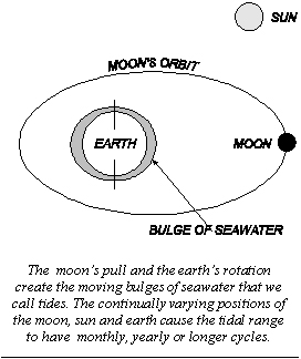
Like tides everywhere, those of the Bay of Fundy result from the moon's gravity dragging
two large bulges of seawater around the earth, one facing the moon and the other exactly
opposite. As the moon makes its daily swing around the earth, the passing of these liquid
bulges brings two high tides per day to a particular place. The fact that the moon's
distance from earth varies and that the sun also contributes a slight gravitational pull
in differing directions causes the actual heights of these bulges to vary at different
times. The Bay of Fundy captures and shapes these watery
bulges into the highest tides in the world. The funnel-like shape of the Bay
and the gradual shallowing along its length causes an inevitable piling up of the water as
it surges up the Bay. It can rise from less than 3.5 metres near the mouth to more than 16
metres at its inner end. However, what really makes for the record breaking tidal heights
is the coming into play of the so called "bathtub effect". In effect, the great
mass of seawater in both the Bay of Fundy and the adjacent Gulf of Maine sloshes back and
forth like water in a giant bathtub. The size of this huge natural basin is such that this
back and forth sloshing has almost the same duration as the twice daily pull of the moon.
The two forces act together to cause an even
greater rise in water level than that caused by the tide alone. However, the gravitational
pull of the sun and moon also fluctuates cyclically over time and this also greatly
influences tidal amplitude. The fact that the moon's monthly orbit about the earth and the
earth's yearly orbit about the moon are not circular but rather elliptical means that the
distances of the moon and the sun from the earth as well as their direction relative to
each other change during each month and each year. These regular cyclical changes give
rise to the twice monthly tidal fluctuations called spring (higher range) and neap (lower
range) tides, as well as to less pronounced yearly fluctuations.
As if this was not
complicated enough, the orbit of the moon about the earth also varies relative to the
orbit of the earth about the sun. The resulting shift in the angle of the moon above and
below the earth's equator during its monthly orbit thus slowly increases and then
decreases in a cycle that takes 18.6 years to complete. This is called the "nodal
cycle", in which tidal amplitude tends to increase
for 9.3 years and then decrease during the next 9.3 years. This change can only be detect by sophisticated measuring
techniques because of all the other daily, monthly and yearly cycles that are taking place
at the same time. Oceanographers are, however, confident that the nodal cycle causes
recurring variations in ocean currents, vertical mixing and water temperatures. These
cyclical oceanographic changes in turn influence ecological processes and populations of
marine organisms. For example, the size of fish catches in the Bay of Fundy and Gulf of
Maine appear to fluctuate in an 18.6 year cycle. However, scientists are not yet sure why
this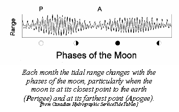 happens. It could be that sea
temperatures slowly become more, and then less, favourable for growth of fish larvae and
juvenile fish. It could also be that the changes in current speed and rates of mixing of
the water result in fluctuations in productivity of phytoplankton and zooplankton, and
thus in the quantity of food available for the fish larvae. Clearly we need to know a lot
more about the effects of such natural cycles
on commercial fish populations. Only then can we make
allowances for them in our efforts to better manage our use of these important living
resources.
happens. It could be that sea
temperatures slowly become more, and then less, favourable for growth of fish larvae and
juvenile fish. It could also be that the changes in current speed and rates of mixing of
the water result in fluctuations in productivity of phytoplankton and zooplankton, and
thus in the quantity of food available for the fish larvae. Clearly we need to know a lot
more about the effects of such natural cycles
on commercial fish populations. Only then can we make
allowances for them in our efforts to better manage our use of these important living
resources.
Malleable
Mudscapes
It is inevitable that the turbulent currents pouring into the Bay each day are slowly
reshaping its shorelines and bottom. The soft rocks of the inner Bay are constantly being
worn down, releasing vast quantities of clay, silt and sand into the water giving it its
characteristic muddy look. Much of this sediment has settled out as the familiar mud flats
and salt marshes that are important to the ecology of the upper Bay. Even more of it has
settled to the seafloor in various parts of the Bay. These mudflats, saltmarshes and
submarine deposits are transitory things that owe their existence to subtle balances in
the competing forces of the tides and currents that deposit sediments and those that erode
them away. Slightly alter either the rate of deposition or the rate of erosion, and over
time the mud layers will change, enlarging, shrinking or disappearing altogether. In
Fundy, prevailing currents seem to be slowly carrying sediments to the northeast into the
inner basins.
There are other natural phenomena that can
also greatly change marine communities and thus obscure the effects of human activities.
Winter ice and gales can be particularly
damaging to marine organisms and their habitats. Thousands of years ago, glaciers scraped
their way across Nova Scotia, crushing everything in their path. A similar thing, but on a
far smaller scale, happens in winter on the Fundy mudflats.
In some years, thick layers of ice form on the saltmarshes and mudflats of
the estuaries. These glacial rafts float, move around and ground with the tides and
currents. Flora, fauna and habitats are crushed and scraped by this grinding ice. The sediments may be deeply gouged or completely
abraded away over large areas. Although the damage can be extensive and severe in some
years, the recovery is usually rapid. By mid
summer ice-scoured and untouched mudflats are usually indistinguishable in appearance and
in numbers and types of animals.
Geological processes, rising sea level,
changing tidal amplitude, ice scour and hurricanes will continue to modify and shape the
Bay of Fundy environment and influence its animal and plant communities. Change is, and
always will be, a fundamental part of living nature. There is little that humans can do to
prevent these natural changes from occurring. It is, nevertheless, important that we learn
as much as possible about these processes so that we can better understand and anticipate
their effects. Also, only by clearly understanding how
ecosystems change naturally can we really determine if particular human
activities are responsible for some of the undesirable changes that we see happening
around us.
Further Reading
The postglacial evolution of the Minas Basin, N.S.; a sedimentological interpretation. C.L. Amos. Journal of Sedimentology and Petrology. Volume 48, pages 965-982. (1978).
A sea-level scenario for Minas Basin. J.S.B. Bleakney. Pages 123-125 In Effects of changes in sea level and tidal range on the Gulf of Maine - Bay of Fundy system. Edited by G.R. Daborn. Acadia Centre for Estuarine Research. Publication Number 1. (1986).
Relative sea-level rise and tidal development in the Fundy tidal system. D.B. Scott and D.A. Greenberg. Canadian Journal of Earth Science. Volume 20, pages 1554-1564. (1983).
Natural and anthropogenic changes in the Bay of Fundy - Gulf of Maine - Georges Bank System. G.R. Daborn and M.J. Dadswell, Pages 547-560 In Natural and Man-Made Hazards, edited by M.I. El-Sabh and T.S. Murty. D. Reidel Publishing Co.(1988).
Written and produced by J.A. Percy
The Clean Annapolis River Project, P.O. Box 395, Annapolis Royal, Nova Scotia B0S 1A0
Tel: (902)532-7533 Fax: (902)678-1253 e-mail: shawboldt@fox.nstn.ns.ca
The Bay of Fundy Ecosystem Project is supported
by Environment Canada, the Department of
Fisheries and Oceans Canada and the Acadia Centre for Estuarine Research.
It may be reproduced with credit to the Clean Annapolis River Project.