Fundy Issue #26
Summer 2005
Saving Special Places:
Protected Areas and the Bay of Fundy
“Many different organizations and individuals
protect parts of the Fundy watershed.
This protection ranges from “short-term” to in perpetuity”,
and the legal guarantee of protection varies from ironclad to negligible.”
Shielding shore and sea
Thus far, efforts in Canada to protect areas of terrestrial and freshwater environments have been more vigorous and effective than those to protect the marine environment. Few marine areas of the Bay of Fundy are even minimally protected from human disturbance. Fishing boats routinely drag heavy nets or dredges that damage sensitive areas of the seafloor, freighters noisily churn through pods of whales basking at the surface, and aquaculture operations degrade benthic habitats in sheltered bays. However, the degradation of coastal marine ecosystems cannot be attributed only to those who work on the sea; people dwelling and working on the nearby land may be even more responsible. Agriculture, forestry, mining, manufacturing, urban sprawl and industrial development throughout the watershed increase freshwater runoff, chemical pollution, nutrient enrichment, sedimentation, litter accumulation and a host of other detrimental impacts in estuaries and coastal waters. Thus, maintaining tracts of coastline and watershed in as natural a state as possible can contribute towards a healthy marine environment.
Over the years, lands around Fundy have been protected from some types of development and human activities. Areas, large and small, have been set aside for many different reasons. Some are primarily for recreational uses such as hiking, cycling, picnicking and swimming. The sheer natural beauty of a Fundy landscape may be reason enough for protecting it. Some protect unique natural features, such as unusual geological formations, places where important historic events occurred, significant buildings or meaningful ruins. Other areas, such as archaeological sites or remnants of old growth forests, may be set aside for scientific research, environmental monitoring or ecological education. Large, relatively undisturbed natural areas have also been set aside to conserve representative examples of particular habitats or ecosystems. Some areas are protected to conserve the habitat of threatened or endangered plants or animals, while others simply promote the well being of populations of game animals. Protective buffer zones may safeguard water supplies or provide attractive green spaces in and around urban areas. Many different organizations and individuals protect parts of the Fundy watershed. This protection ranges from "short-term" to "in perpetuity", and the legal guarantee of protection varies from ironclad to negligible. Given the diversity of protectors, motives and degrees of protection, it is not surprising that the pattern of "protected" areas that has evolved in and around Fundy is complex, disjointed, confusing and a challenge to evaluate.
Who’s Protecting What, Where – and Why?
 International
– Canada has international commitments to conserve some of the
Bay's coastal areas. "Ramsar sites", designated by the Convention on Wetlands
of International Importance especially as Waterfowl Habitat, which
was agreed to at a conference in 1971 in the Iranian city of Ramsar, are
primarily intended to conserve wetland habitat for waterfowl. However, this
agreement, now signed by 146 nations, has expanded to include the protection of
wetlands for the maintenance of general biodiversity as well as for benefits to
human communities. There are now 1458 wetlands, totaling more than 122 million
hectares, slightly larger than Ontario, on the Ramsar List of Wetlands of
International Importance. Of the 36 sites in Canada, four are in the upper
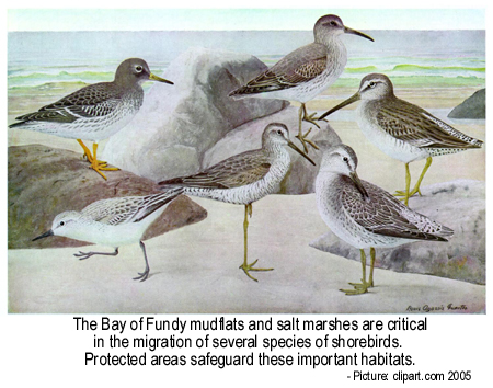
Bay of Fundy; namely, Chignecto (1,020 ha), Mary’s Point (1,200 ha), Shepody Bay
(12,200 ha), and the entire Southern Bight of Minas Basin (26,500 ha). These
Fundy sites attest to the importance of the coastal salt marshes and mudflats of
the upper Bay as feeding and staging areas for migratory shorebirds and
waterfowl. Another international body, the Western Hemisphere Shorebird
Reserve Network (WHSRN) is a coalition of more than 140 public and private
organizations, formed to promote the conservation of migratory shorebirds and
the protection of their critical habitats, particularly major breeding sites,
migration staging areas and wintering grounds scattered throughout the Americas.
There are 60 such reserves in eight different countries, stretching from Alaska
to Tierra del Fuego. The two sites in the Bay of Fundy, Shepody Bay and the
Southern Bight of the Minas Basin, are critical feeding and roosting areas for
huge flocks of Semipalmated Sandpipers and other migrating shorebirds. However,
such designation as a Ramsar or a WSHRN site does not confer any specific legal
protection, although such international recognition does attract attention and
facilitates conservation, education and research.
International
– Canada has international commitments to conserve some of the
Bay's coastal areas. "Ramsar sites", designated by the Convention on Wetlands
of International Importance especially as Waterfowl Habitat, which
was agreed to at a conference in 1971 in the Iranian city of Ramsar, are
primarily intended to conserve wetland habitat for waterfowl. However, this
agreement, now signed by 146 nations, has expanded to include the protection of
wetlands for the maintenance of general biodiversity as well as for benefits to
human communities. There are now 1458 wetlands, totaling more than 122 million
hectares, slightly larger than Ontario, on the Ramsar List of Wetlands of
International Importance. Of the 36 sites in Canada, four are in the upper
Bay of Fundy; namely, Chignecto (1,020 ha), Mary’s Point (1,200 ha), Shepody Bay
(12,200 ha), and the entire Southern Bight of Minas Basin (26,500 ha). These
Fundy sites attest to the importance of the coastal salt marshes and mudflats of
the upper Bay as feeding and staging areas for migratory shorebirds and
waterfowl. Another international body, the Western Hemisphere Shorebird
Reserve Network (WHSRN) is a coalition of more than 140 public and private
organizations, formed to promote the conservation of migratory shorebirds and
the protection of their critical habitats, particularly major breeding sites,
migration staging areas and wintering grounds scattered throughout the Americas.
There are 60 such reserves in eight different countries, stretching from Alaska
to Tierra del Fuego. The two sites in the Bay of Fundy, Shepody Bay and the
Southern Bight of the Minas Basin, are critical feeding and roosting areas for
huge flocks of Semipalmated Sandpipers and other migrating shorebirds. However,
such designation as a Ramsar or a WSHRN site does not confer any specific legal
protection, although such international recognition does attract attention and
facilitates conservation, education and research.
Federal
- The Federal government has created other conservation areas in Fundy that are protected by considerably sharper "legislative teeth" than the international agreements. Many such sites, designated by acts and regulations of parliament, are largely the responsibility of Environment Canada. There are four National Migratory Bird Sanctuaries around Fundy, two in New Brunswick at Machias Seal Island and Grand Manan, and two in Nova Scotia at Amherst Point and Kentville. These sanctuaries, set up under the Migratory Birds Convention Act (1917), protect species that congregate to breed, feed or stage during migration in areas that may be vulnerable to disturbance by humans. It is illegal to hunt, trap, possess birds or disturb their nests in these sanctuaries. Some, such as Machias Seal Island, are even more stringently regulated and access is restricted. National Wildlife Areas (NWA), created under the Canada Wildlife Act (1973), have a somewhat broader protective scope. While they may protect migratory bird populations, they are mainly intended to protect concentrations of rare or threatened plants and animals or conserve areas of unusual or special wildlife habitat. Traditional pursuits such hunting, trapping, fishing and hiking are usually permitted in these areas. There are five NWAs within the Bay of Fundy watershed. In New Brunswick, these include a large wetland complex at Portobello Creek on the St. John River near Fredericton, and the salt marshes and mudflats of Shepody Bay and Tintamarre on the Tantramar Marshes. In Nova Scotia they comprise the intertidal mudflats at Chignecto in Cumberland Basin and also Boot Island, with its seabird colonies and surrounding mudflats, in the Minas Basin near Wolfville. Isle Haute, an 83-hectare, cliff-bound island at the western extremity of the Minas Channel, rises over 100 metres above the surging tidal currents. Scientists from the Nova Scotia Museum of Natural History catalogued its diverse flora and fauna, as well as its many geologic, archaeological and historic attributes in 1997. The Canadian Coastguard has long operated a light station on the island’s peak. Environment Canada is now working to find a way to protect the island, possibly by designating it a National Wildlife Area. The Canada Wildlife Act also provides for the creation of National Marine Wildlife Areas (NMWA). A recent proposal to protect coastal foraging habitat of threatened seabirds near Vancouver Island could create Canada’s first such NMWA.The Department of Fisheries and Oceans (DFO) is another federal department with a key role to play in protecting Fundy. In 1994, DFO designated two Right Whale Conservation Zones, in areas where these endangered marine mammals congregate in summer, to reduce the likelihood of ship strikes and entanglement in fishing gear. One is located in the Roseway Basin off the southwestern tip of Nova Scotia and the other in the Bay of Fundy near Grand Manan. The Fundy Traffic Centre radios ships entering the Bay to alert them to the conservation zone and warn them if whales are present. Additionally, in 2003 the International Maritime Organization of the United Nations rerouted the main shipping lane in the Bay around the conservation zone.
Under the Fisheries Act, DFO also has the responsibility for protecting fish habitat in the sea, rivers and lakes. With its broad powers to regulate fishing, it has tended to devote itself mostly to enhancing and sustaining harvestable fish stocks. It rarely used its regulatory authority to protect marine habitats and biological communities from destructive fishing practices. Furthermore, by its own account its general approach to ocean management has been "fragmented, exceedingly complex, lacks transparency and is focused on solving problems after they appear". However, the collapse of groundfish and other fish stocks has prompted a major reevaluation of management practices and a greater appreciation of the conservation value of marine protected areas. The Oceans Act (1996) which came into force in January 1997, provides for the creation of a network of Marine Protected Areas (MPAs), and gives DFO, with other agencies and partners, important new roles in protecting Canada’s marine ecosystems, including those of the Bay of Fundy. More recently the Minister of Fisheries and Oceans was given the task of guiding the development of an Oceans Action Plan to give Canada a "significant leadership role internationally in promoting modern oceans governance and improved management".
Parks Canada is another Federal Agency with a significant role in protecting important natural and historic areas around the Bay. The Canada National Parks Act provides for the creation of National Parks to conserve exceptional representative areas of natural landscapes within the country’s different bioregions. While such parks are primary created to protect ecosystem integrity and wildlife and habitat diversity, they are also places where people are encouraged to enjoy the outdoors and appreciate the natural features of the park. There is an ongoing effort to maintain a reasonable balance between these potentially conflicting goals. Fundy National Park on the shores of Chignecto Bay is the only National Park located within the Fundy Watershed, although Nova Scotia’s Kejimkujik National Park is very close. Fundy National Park incorporates the last large wilderness area in southern New Brunswick and features a diverse array of common and rare animals and plants. It comprises two principal ecosystem types, the marine coastal environment of the Bay of Fundy and a portion of the Appalachian Mountain range know as the Caledonia Highlands, an upland plateau area with deep valleys carved by coastal rivers.
National Historic Sites (NHS), also administered by Parks Canada, protect and display features of significance to the nation’s history. Many may secondarily also protect natural areas. For instance, those located directly on the shoreline, such as Fort Beausejour overlooking Cumberland Basin, the St. Andrews Blockhouse on the St. Andrews waterfront, and Fort Anne on the Annapolis Basin, protect the coast from commercial development and allow public access to the shore. The Habitation on the Annapolis Basin, Grand Pré near Wolfville, St. Croix Island in southwestern New Brunswick and the Roosevelt-Campobello International Park located along the Canada-U.S. boundary at the mouth of the Bay, are other historic sites protecting coastal areas.
 Provincial
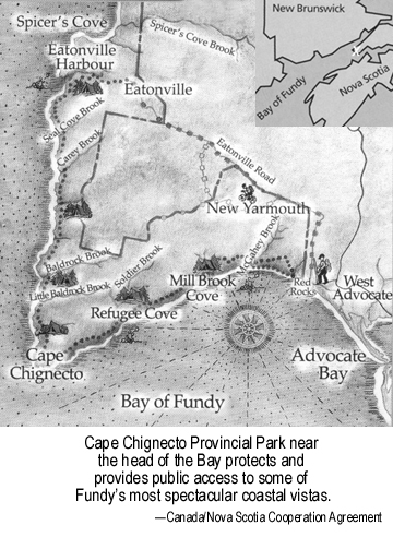
Provincial governments also protect specific parcels of land within the Fundy watershed. Both Nova Scotia and New Brunswick maintain a network of Provincial Parks legislated under the Provincial Parks Act 1989 and the Parks Act (Provincial Parks) 1999, respectively. In New Brunswick there are eight provincial parks in the Fundy coastal region, with a total area of 1,114 hectares; the three largest being Herring Cove (424 ha) on Campobello Island, New River Beach (382 ha) near Pocalogan, and The Anchorage (175 ha) on Grand Manan Island. In contrast, Nova Scotia has 13 provincial parks bordering the Bay of Fundy, with a total area of 6,326 ha. The newest is Cape Chignecto Provincial Park, which at 4,200 ha is the largest in the province. It protects 35 kilometres of dramatic, cliff-lined coast jutting into the upper Bay. Other large parks include Blomidon Provincial Park (909 ha) near Kentville and Five Islands Provincial Park (519 ha) near Economy. Many provincial parks were created in the 1950’s and 60’s at a time of expanding highway systems, increasing automobile ownership and a growing interest in "touring". They were primarily designed as roadside rest areas, picnic parks, camping parks or to allow public access to beaches. The revised Nova Scotia legislation specifically recognizes that many of its provincial parks also "conserve Nova Scotia’s outstanding heritage resources". The Department of Natural Resources administers all such parks in Nova Scotia. During the 1990’s many smaller provincial parks in New Brunswick were closed or leased to private operators. The rest are administered either by the Department of Natural Resources and Energy, or in the case of the eight most intensively used and developed ones, by a department tellingly named Business New Brunswick.
Both provinces have also designated tracts of Crown Land as Wilderness areas, Ecological Reserves, Conservation Areas, Game Sanctuaries or Wildlife Management areas. These are accorded different levels of protection depending upon their particular designation and conservation purpose. In New Brunswick, such lands, managed by the Department of Natural Resources and Energy, are designated as either class 1 or 2. Class 1 lands are protected from virtually all activities, while class 2 are available for sustainable recreational uses but protected from industrial and commercial uses. Examples of class 1 areas around the Fundy region include Wilson’s Brook (76 ha) near Hopewell Cape and Little Salmon River (705 ha) almost midway between Saint John and Alma. The Loch Alva region in southwestern New Brunswick has 38 ha designated as class 1 and an additional 21,925 ha designated as class 2. Other large class 2 areas include the Canoose Flowage (3,900 ha) near the Maine border and the Caledonia Gorge (2,856 ha) near Chignecto-Shepody Bays. In Nova Scotia the Department of Natural Resources is presently reviewing the existing Wildlife Management Areas and Game Sanctuaries. Examples in the Fundy region include the 22,800 ha Chignecto Game Sanctuary at the head of the Bay, the much smaller Debert Wildlife Management Area near Truro, the Minas Basin and Dewey Creek Wildlife Management Areas near Kentville, and the Upper Clements Wildlife Sanctuary on the Annapolis Basin. The Department is also proposing the creation of an East Amherst-Missaguash Wildlife Management Area on the shores of Cumberland Basin.
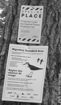
 Both
provinces also have legislation to protect other areas of special natural,
historic or cultural interest. Nova Scotia has the Special Places Protection
Act 1989, whose purpose is clearly indicated by its full name: "An Act to
Provide for the Preservation, Regulation and Study of Archaeological and
Historical Remains and Palaeontological and Ecological Sites." The
Legislation, which can also apply to underwater sites, protects areas that are
"considered important parts of the natural or human heritage of the province"
and provides for their "preservation, protection, regulation, acquisition and
study". An example in the Fundy region is the 1990 designation of Wasson’s Bluff
near Parrsboro, where 200 million year old fossil dinosaur assemblages are
eroding from the rock strata. Another 130 ha site at Debert, near to the shores
of the Minas Basin, was protected by this legislation when archaeological
surveys recovered over 700 stone artifacts from 10,600 year old palaeo-Indian
encampments in the area. The remarkable story of these ancient Maritimers is
told at length in Fundy Issue number 24, "Living Lightly on Land and Water:
Native People and the Bay of Fundy". New Brunswick’s comparable legislation
is the "Historic Sites Protection Act 1997", which focuses principally on
historic and anthropological sites including archaeological digs, earthworks or
buildings deemed to be of historic importance. This legislation was used in 1998
to protect a small rocky ledge overlooking Saint John Harbour, after
archaeologists found a remarkable assemblage of tools, weapons and soapstone
pots dating to at least 4,000 years ago.
Both
provinces also have legislation to protect other areas of special natural,
historic or cultural interest. Nova Scotia has the Special Places Protection
Act 1989, whose purpose is clearly indicated by its full name: "An Act to
Provide for the Preservation, Regulation and Study of Archaeological and
Historical Remains and Palaeontological and Ecological Sites." The
Legislation, which can also apply to underwater sites, protects areas that are
"considered important parts of the natural or human heritage of the province"
and provides for their "preservation, protection, regulation, acquisition and
study". An example in the Fundy region is the 1990 designation of Wasson’s Bluff
near Parrsboro, where 200 million year old fossil dinosaur assemblages are
eroding from the rock strata. Another 130 ha site at Debert, near to the shores
of the Minas Basin, was protected by this legislation when archaeological
surveys recovered over 700 stone artifacts from 10,600 year old palaeo-Indian
encampments in the area. The remarkable story of these ancient Maritimers is
told at length in Fundy Issue number 24, "Living Lightly on Land and Water:
Native People and the Bay of Fundy". New Brunswick’s comparable legislation
is the "Historic Sites Protection Act 1997", which focuses principally on
historic and anthropological sites including archaeological digs, earthworks or
buildings deemed to be of historic importance. This legislation was used in 1998
to protect a small rocky ledge overlooking Saint John Harbour, after
archaeologists found a remarkable assemblage of tools, weapons and soapstone
pots dating to at least 4,000 years ago.
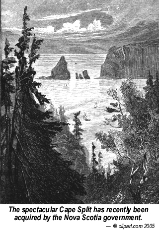
Cape Split, a basaltic promontory jutting into the Minas Channel has long been a favourite haunt of hikers and naturalists. Privately owned for generations, a 250 hectare tract, encompassing the headland and most of the hiking trails was purchased in the summer of 2002 by the Nova Scotia Government, thus ensuring its protection in perpetuity. The Department of Natural Resources is conducting an environmental assessment of the site as part of the development of a long-term management plan.
Municipal
- Many communities around the Bay of Fundy protect stretches of nearby coastline for a variety of reasons, usually to conserve a local beach or create a small coastal park. Some have constructed hiking or biking trails to cater to the growing interest in ecotourism and outdoor natural experiences. For example, in Nova Scotia there is the Delap’s Cove Wilderness Trail operated by the Annapolis County Recreation Department. It consists of a pair of connected 2-km loop trails through 50 ha of coastal woodland and along the rocky Fundy shore. In nearby Annapolis Royal, a 15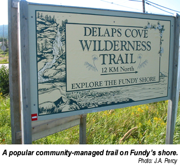 ha section of former saltmarsh, reclaimed
centuries ago as agricultural dykeland, has been flooded to create a freshwater
impoundment and wildlife park, featuring the 1.2-km French Basin Trail.
Similarly, in New Brunswick, the Town of Sackville partnered with the Canadian
Wildlife Service and Ducks Unlimited to create the outstanding Sackville
Waterfowl Park, a 22 h wetland complex bordering the Tantramar Marshes. Its 3.5
km of trails and boardwalks wind through marsh, meadows, woodland and ponds that
are home to over 150 species of birds and almost 250 varieties of wild plants.
ha section of former saltmarsh, reclaimed
centuries ago as agricultural dykeland, has been flooded to create a freshwater
impoundment and wildlife park, featuring the 1.2-km French Basin Trail.
Similarly, in New Brunswick, the Town of Sackville partnered with the Canadian
Wildlife Service and Ducks Unlimited to create the outstanding Sackville
Waterfowl Park, a 22 h wetland complex bordering the Tantramar Marshes. Its 3.5
km of trails and boardwalks wind through marsh, meadows, woodland and ponds that
are home to over 150 species of birds and almost 250 varieties of wild plants.
Non Profit Groups
– Many non-profit organizations also protect natural habitats throughout the Maritimes. Three "nature trusts", the national Nature Conservancy of Canada (NCC) and the provincial New Brunswick and Nova Scotia Nature Trusts (NBNT and NSNT), all have conservation projects in the Fundy region. These groups acquire ecologically sensitive areas by purchase or donation and also work with landowners to secure easements and other conservation agreements. The NCC owns several ecologically important sites along the Fundy coast, including 486 ha on Brier Island near Digby, 8 ha on Spencers Island in Minas Basin, and coastal lands at Dorchester Cape and Johnson’s Mills in Shepody Bay, both important staging areas for migrating shorebirds. The Conservancy also owns 313 ha of wetland next to the candidate marine protected area at Musquash (see below) and is seeking to acquire an additional 890 ha nearby. Funds are also being raised to buy the 22 ha Simpson Island in Passamaquoddy Bay. The NBNT manages 14 nature preserves along the Fundy coast, including a 35 ha complex of 7 islands and a nearby mainland property in L’Etang Inlet, coastal wetlands at Cape Enrage in Chignecto Bay, and 8 ha at Saints Rest Marsh, next to the Irving Nature Park near Saint John. The NSNT owns 7 properties within the Fundy watershed, including the two Brothers Islands (6 ha) near Parrsboro, the Wolfville Ridge (47 ha) on the opposite side of the Minas Basin, a 162 ha parcel of woodland on the North Mountain near Aylesford, and 73 ha around Cloud Lake in Annapolis County. The NSNT has also negotiated 3 easements and 62 Stewardship Agreements with owners' of properties bordering the Bay. Such conservation agreements are particularly important in Nova Scotia, where over three-quarters of the land area is privately owned (compared to only 50% in New Brunswick). Conservation easements are legally binding agreements by which certain rights to a property are held by a person or organization other than the actual landowner. The easements continue to be valid even if the property is sold or transferred to another owner. In contrast, Stewardship Agreements are essentially handshake commitments to protect natural features on private property. The landowner agrees to notify the Nature Trust of any plans to alter or sell the property, so that the trust can explore ways to reduce impacts or discuss conservation options with the new owner. Some Maritime Universities have also acquired coastal lands, often by bequest, which they protect and use for research or education. For example, Acadia University owns property on Partridge Island near Parrsboro.Ducks Unlimited (DU) is another no-profit organization that plays a significant role in habitat protection around the Bay and indeed right across North America. Its main interest is in the conservation, restoration and management of wetlands and associated habitats to sustain waterfowl populations, but it also promotes conservation of wetlands flora and fauna in general. Around the Bay of Fundy, DU manages over 7,000 ha of wetlands and associated habitat, nearly equal to the area of all the provincial parks in the watershed. The majority of these holdings are small wetland tracts of less than 25 ha and many were former salt marsh/dykeland areas that have been transformed into freshwater impoundments. Some of the larger wetland areas include 2,600 ha near the Missaguash River, 850 ha at nearby Amherst Point, over 650 ha of the nearby John Lusby Salt Marsh and 500 ha on Brier Island.
Corporations
– In both provinces several tracts owned by large corporations have been protected for conservation and public recreational use. For example, in Nova Scotia’s Annapolis County the Bowater-Mersey Paper Company has created a small "pocket wilderness" park at Mickey Hill and also set aside an adjacent large tract on Lamb’s Lake as an Old Growth Reserve under the company’s Unique Areas Program. Similarly, in New Brunswick, the forested peninsula and adjacent salt marsh at Taylor’s Island, near the mouth of Saint John Harbour, owned by the Irving family, was opened to the public in 1992. This 225 ha Irving Nature Park attracts some 150,000 visitors annually and also offers environmental education and nature interpretation programs.
 Managing
the Musquash
Managing
the Musquash
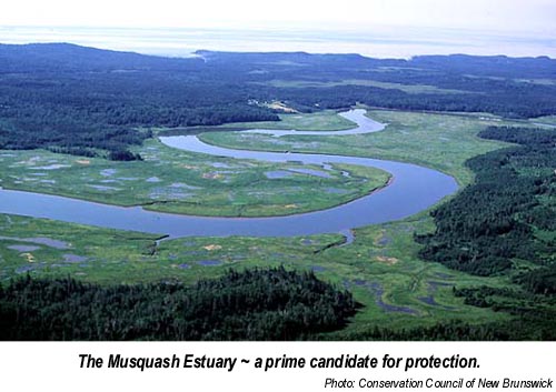
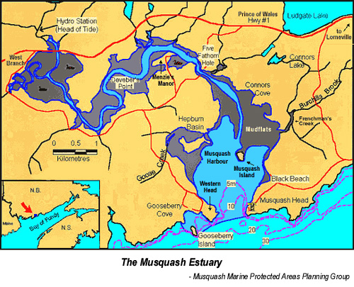 Brunswick in partnership with the Fundy
North Fishermen’s Association initially proposed protecting the 27 km2
estuary under the provisions of the Oceans Act in late 1998. A community
group, Friends of Musquash, and a Musquash Marine Protected Areas Planning Group
are now working closely with DFO and the Provincial Government to determine how
best to conserve, protect and manage this unique area. When the area is
officially designated, it will be the Bay of Fundy’s first Marine Protected Area
under the Oceans Act, but hopefully not its last.
Brunswick in partnership with the Fundy
North Fishermen’s Association initially proposed protecting the 27 km2
estuary under the provisions of the Oceans Act in late 1998. A community
group, Friends of Musquash, and a Musquash Marine Protected Areas Planning Group
are now working closely with DFO and the Provincial Government to determine how
best to conserve, protect and manage this unique area. When the area is
officially designated, it will be the Bay of Fundy’s first Marine Protected Area
under the Oceans Act, but hopefully not its last.
Expanding the Protection
Protected areas may be particularly important in the outer Bay, where shipping, fishing, aquaculture and industrial activity are concentrated. Over the years there have been a number of major industrial developments proposed in the outer Bay region and recently concerns have arisen about a proposed Liquid Natural Gas terminal in nearby Eastport, Maine. In particular, highly productive and diverse hard bottom subtidal communities characteristic of the current-swept channels adjacent to the islands flanking the mouth of the Bay such as around Grand Manan, the Quoddy Region and Brier Island, should be protected. Marine biologist Martin Thomas reports that the tides force huge volumes of food-laden seawater through the narrow channels providing a "virtually inexhaustible" food supply for "a fantastic population density of filter feeding organisms". A study on the feasibility of creating a National Marine Conservation Area in the West Isles area was suspended in 1986. However, Parks Canada still considers this to be a National Area of Canadian Significance. Recently, a scientific working group convened by the Marine Conservation Biology Institute identified this as a high priority area for protection, and many other scientists have recommended that DFO consider establishing a Marine Protected Area in the region. Brier Island, on the other side of the Bay, is also an area of strong tidal currents and intense water mixing. The region is very productive and home to an abundance of fish, seabirds and marine mammals. It is also on the flyways of many migratory bird species and is thus a popular destination for birders. While the Nature Conservancy of Canada protects some of the Island, there have been calls for more rigorous protection of more of the island as well as the surrounding sea. Parks Canada considers the shoals to the northeast of Brier Island to be a National Area of Canadian Significance and the Marine Conservation Biology Institute scientific working group identified Brier Island as a high priority area for protection. Other scientists also recommend that the Brier Island region be evaluated as a possible Marine Protected Area.
 There
are salt marshes near Dipper Harbour, Chance Harbour, and St. Martins as well as
adjacent to the Musquash Candidate Protected Area that conservation groups are
interested in acquiring and protecting. Hugh Akagi, Chief of the Passamaquoddy
Peoples, has also forcefully expressed the interest of the native peoples of
southwestern New Brunswick in protecting the Ship’s Cove portion of McMaster
Island in Passamaquoddy Bay, one of the "most beautiful and tranquil locations
in the region". The native peoples have long used this area for hunting, fishing
and ceremonial activities, and consider it an important link to their rich
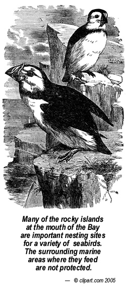
culture and heritage. Many rocky islands flanking the mouth of the Bay are
nesting sites for waterfowl and seabirds such as Eiders, Black Legged
Kittiwakes, Cormorants, Northern Gannets, Razorbills and Atlantic Puffins. While
the principal colonies are protected, there are still many others that are
vulnerable to disturbance. Furthermore, there is little protection for the
marine waters around these island sanctuaries where the birds forage for
themselves and their chicks; marine buffer zones are essential in such areas.
There
are salt marshes near Dipper Harbour, Chance Harbour, and St. Martins as well as
adjacent to the Musquash Candidate Protected Area that conservation groups are
interested in acquiring and protecting. Hugh Akagi, Chief of the Passamaquoddy
Peoples, has also forcefully expressed the interest of the native peoples of
southwestern New Brunswick in protecting the Ship’s Cove portion of McMaster
Island in Passamaquoddy Bay, one of the "most beautiful and tranquil locations
in the region". The native peoples have long used this area for hunting, fishing
and ceremonial activities, and consider it an important link to their rich
culture and heritage. Many rocky islands flanking the mouth of the Bay are
nesting sites for waterfowl and seabirds such as Eiders, Black Legged
Kittiwakes, Cormorants, Northern Gannets, Razorbills and Atlantic Puffins. While
the principal colonies are protected, there are still many others that are
vulnerable to disturbance. Furthermore, there is little protection for the
marine waters around these island sanctuaries where the birds forage for
themselves and their chicks; marine buffer zones are essential in such areas.
Gordon Fader, a marine geologist formerly at the Bedford Institute of Oceanography and Dave Wildish, an ecologist at the St. Andrews Biological Station, suggest that extensive "bioherms", seafloor reefs formed by horse mussels, be protected from bottom trawling and dredging. These unusual structures, kilometers long, up to 30 m wide and as much as 3 m in height are highly productive. They are abundant in the mid Bay, running parallel to the New Brunswick and Nova Scotia coastlines. Fader also suggests that seafloor areas adjacent to the mouth of the Bay, such as the Browns Bank glacial moraine and the Northeast Channel, with its unique coldwater coral beds, should also be protected.
Vulnerable coastal areas in the upper Bay also require protection. As we have seen, Fundy National Park is located on the coast. On its landward side, it has a protective buffer in the holdings of the Greater Fundy Ecosystem Research Group and the Fundy Model Forest. However, its seaward boundary is the mean high water line and none of the nearby marine environment is within the Park’s jurisdiction or directly protected by it. Parks Canada could create a National Marine Conservation Area (NMCA) adjacent to the Park as a marine buffer. Although critical habitats for shorebirds and waterfowl in the upper Bay have been recognized as important by international conventions, many still have no real legal protection, monitoring or enforcement. A patchwork of critical roosting areas is being protected by diverse groups, but other areas should be considered for more rigorous protection, including the intertidal mudflats of Shepody Bay and the Southern Bight of Minas Basin. Along the Hants Shore of the Minas Basin, a local citizen’s group is lobbying actively for a marine protected area along their coast. They are concerned that the intensive commercial digging of baitworms on the intertidal mudflats may be degrading the habitat and interfering with shorebirds feeding in the area. They would like to see the area protected and promoted as a destination for ecotourism.
The
Bay of Fundy Biosphere Initiative BoFBI is working towards establishing a
Biosphere Reserve in the Upper Bay as a means of conserving coastal areas and
natural resources. Such reserves, created voluntarily by communities under the
auspices of UNESCO, are "based on the understanding that human communities live
and function within larger ecosystems, and that the health and integrity of both
communities and ecosystems depend on
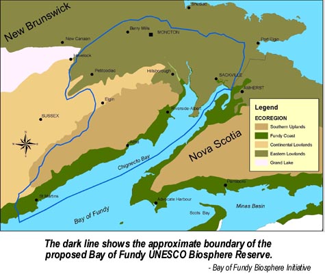 enhancing that relationship". There are 12
biosphere reserves across Canada that typically consist of a well protected core
area, such as a National Park, an adjacent buffer zone and a surrounding zone of
cooperation. All stakeholders in the region work together to find ways of
fostering sustainable economic and social development without compromising the
local environment or the natural resources. An application is being prepared for
the designation of the New Brunswick side of the upper Bay surrounding Fundy
National Park as a UNESCO Biosphere Reserve.
enhancing that relationship". There are 12
biosphere reserves across Canada that typically consist of a well protected core
area, such as a National Park, an adjacent buffer zone and a surrounding zone of
cooperation. All stakeholders in the region work together to find ways of
fostering sustainable economic and social development without compromising the
local environment or the natural resources. An application is being prepared for
the designation of the New Brunswick side of the upper Bay surrounding Fundy
National Park as a UNESCO Biosphere Reserve.
Coordinating Conservation
Further Information
Canada and the Ramsar Convention: The Convention on Wetlands of International Importance. Canadian Wildlife Service, Environment Canada, Ottawa ON. 20 pages. (1999).
Habitat Lost: Taking the Pulse of Estuaries in the Canadian Gulf of Maine. J. Harvey, D. Coon and J. Abouchar, eds. Conservation Council of New Brunswick, Fredericton, NB. 81 pages. (1998).
Identification of Significant Marine and Coastal Areas in the Bay of Fundy. M-I. Buzeta, R. Singh, and S. Young-Lai. Canadian Manuscript Report on Fisheries and Aquatic Science. Number 2635, 177 pages + figures. (2003)
Planning for Representative Marine Protected Areas: A Framework for Canada’s Oceans. J. Roff and J. Day. World Wildlife Fund Canada, Toronto, ON. 147 pages. (2000).
Advances in marine conservation: the role of marine protected areas. M.T. Agardy. Trends in Ecology and Evolution. Volume 9, pages 267 to 270 (1994).
Informative Websites
Ramsar Convention:
www.ramsar.orgWestern Hemisphere Shorebird Reserve Network - www.manomet.org/WHSRN
Fundy National Park - www.pc.gc.ca/pn-np/nb/fundy/
NS Provincial Parks - www.parks.gov.ns.ca
NB Provincial Parks - www.canadatrails.ca/nb/parks.html
Musquash candidate protected area - www.musquashmpa.ca
Canadian Biosphere Reserves Association - www.biosphere-canada.ca
The Environmental Conservation Branch
This Fundy Issue is financially supported by:
Environment Canada - Atlantic Region
Dartmouth, Nova Scotia
The views expressed herein are not necessarily those of Environment Canada or other BoFEP partners.
Written and designed by J.A. Percy,
SeaPen Communications, Granville Ferry. N.S.
e-mail: bofep@auracom.com
Acknowledgement
Thanks to Maria-Ines Buzeta, Dave Duggan and Peter Wells for reviewing
drafts of the manuscript.
Fundy Issues may be reproduced and circulated for educational or other non-commercial purposes with credit to the
Bay of Fundy Ecosystem Partnership