FUNDY ISSUES #5
AUTUMN 1996
DREDGING FUNDY'S DEPTHSSeabed Mining in the Bay of Fundy
" The geological history of coastal Nova Scotia ........
has been particularly favourable for the formation of large
aggregate deposits beneath the surrounding shallow waters"
For many people, the expression "marine resources" conjures up images of boatloads of fish, lobsters or scallops. Humans inhabiting the Fundy shores have depended on these living, renewable resources for untold centuries, and even today they are still important to many coastal communities. However, in recent decades there has been a growing interest in other valuable harvests from the sea, particularly some that are non-living. The most prominent of these are the gas and oil being extracted from subsea reservoirs in many parts of the world. Interest is also increasing in extracting other valuable mineral resources such as gold, titanium, tin and diamonds from promising marine deposits. Even such seemingly commonplace materials as sand and gravel (collectively termed "aggregate") are now being mined from undersea sources, particularly in Europe and Japan, where up to 20% of the supply comes from beneath the sea. In most countries sand and gravel are used in huge amounts for such things as cement for buildings, asphalt for road construction and for many other specialized uses.
A 1987 estimate indicated that 12 million tonnes of aggregate is produced annually in Nova Scotia, with a value of $55 million. Until recently, most of the aggregate used in the maritimes has been extracted either from quarries on land or from beaches. However, there have been growing pressures to look elsewhere. The Beach Preservation and Protection Act of 1975 banned removal of material from beaches. Existing accessible deposits are being rapidly depleted and in many areas, large, dusty and noisy quarries are becoming unacceptable on environmental, aesthetic or health grounds. It is not surprising, therefore, that developers are eagerly looking for new deposits to meet their future needs. The seafloor around our shores, particularly in the Bay of Fundy, offers promise of a virtually limitless supply of high quality material.
Assessing Aggregate Assets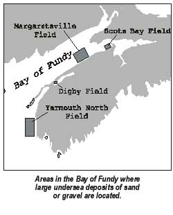
The geological history of coastal Nova Scotia, involving the advance and retreat of massive glaciers and large changes in sea level, has been particularly favourable for the formation of large aggregate deposits beneath the surrounding shallow waters. Since the 1960's, scientists from the Geological Survey of Canada and elsewhere have surveyed the Atlantic coastal shelf and mapped and sampled many of the promising aggregate deposits. The initial mapping used echograms (depth sounders that bounce sound waves off the sea floor), which provided basic information on sediment type and seabed profile. In the 1970's, sidescan sonar (using sideways pointing depth sounders towed behind a ship) and high resolution seismic reflection technology (based on setting off small explosions at the sea surface and measuring, with towed sensors, the nature of the echoes returning from the seafloor and its underlying layers) were introduced. These techniques provided a much more detailed picture of the seabed.
Since the early 1990's an even more sophisticated survey method has been used to obtain dramatically detailed pictures, with three dimensional, photographic quality. This "multibeam technology" uses a survey vessel with an array of transducers mounted on the ship's hull. The transducers send and receive sound waves of varying frequencies to and from the seafloor in a fan shape. As the ship moves forward, its sensors sweep a wide swath and record a highly detailed "shaded relief image" (in which shadows simulate light coming from a particular direction, giving a three dimensional depth to the picture). The resulting images of the seabed are almost like aerial photographs taken on land, and show in great detail major features on the seafloor. Unlike earlier survey methods which only sampled scattered points or widely separated, narrow lines, a multibeam survey covers the entire area over which it sweeps. It thus provides a continuous picture of the seafloor. Furthermore, the different sound intensities can be used to determine the type of bottom material (mud, sand etc). These images also provide clues about how the seafloor formed and how it is changing in response to currents and other processes. This new technology will be of great help in learning more about submarine geological processes, in locating new aggregate deposits and in monitoring the seafloor for changes caused by natural processes and human activities.
The "Golden" Sands of FundyIn the Bay of Fundy, there is growing commercial interest in several large fields of submarine sand "dunes" or waves, heaped up by the powerful tidal currents. One such area in Scots Bay, southwest of Cape Split, may contain up to 35 million cubic meters of coarse sand and fine-grained gravel. This material is of better quality than that found in most coastal areas, because the exceptional currents have sorted the deposits by particle size and washed out most of the undesirable mud and silt. Other extensive deposits of sand are located offshore from Margaretsville and at the mouth of the Bay near Yarmouth. Promising deposits of gravel also occur in some of these areas as well as in the Annapolis Basin.
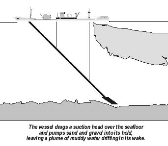
Although not yet used in Canada, the technology for economically extracting these deposits from the seafloor in water up to 40 meters in depth has been developed in Britain and other European countries. In Japan, where shallow-water deposits are being depleted, mining is done in water up to 100 meters deep. Many of the most promising deposits along the Nova Scotia coast are found at more manageable depths of less than 70 meters. The method commonly used for recovering these submarine sand and gravel deposits is with a "trailer suction dredge". This vessel is equipped with a high capacity pump and a large diameter pipe at the end of which is a large dredge head. The dredge head is lowered to the sea floor, and as the ship moves forward at about 1 knot, the bottom material sucked up by the dredge head is pumped up the pipe to the vessel. The material is washed through screens to remove any mud, and the sand and gravel is dumped into the holds. When the ship is dredging, a plume of silt can be released into the surrounding water from this washing process and from water draining from the holds. As the ship criss-crosses an area it excavates trenches in the seafloor. These are usually about a foot deep and 6 feet wide. With continued dredging in a particular area, the entire seafloor may be lowered significantly.
Harvesting Habitat?There is growing concern about the potential environmental impacts of proposed subsea mining in Canada's coastal waters. Some scientists feel that impacts will be "potentially serious, but highly variable", while others are confident that European and Japanese experiences show that the "environmental and fisheries concerns can be accommodated". The most obvious impact is that the dredging removes living material from the bottom and destroys plants and animals that are sucked up. If only relatively small areas are dredged, animals from surrounding untouched areas can rapidly move into the disturbed area and recolonize it. As well, not all areas of interest contain a rich flora and fauna. Some of the dynamic sandwaves in the Bay of Fundy are virtually barren. However, much of the seafloor is the "habitat" for many different sea creatures, including some of commercial importance. Removing these surface layers is, in effect, "harvesting habitat". If the dredging changes the nature of the bottom material sufficiently, its biological communities may have great difficulty in reestablishing themselves. This occurred in Norway, where an intensive scallop fishery repeatedly dragged heavy dredges across the seabed. This removed much of the thin gravel layer and exposed the underlying mud, ultimately causing the scallop fishery to collapse. Some of the coastal deposits around Nova Scotia form a similar thin veneer of gravel and geoscientists such as Gordon Fader of the Geological Survey of Canada caution that there is a "potential for environmental degradation of fishery habitat associated with the release of fine-grained sediments to the water column and the exposure of subsurface muddy sediments". However, Fader is also quick to point out that mining in some areas might actually improve fish habitat. For instance, in the Scots Bay sand wave field the sand deposits overly a gravel layer. He suggests that "removal of the sand wave field through marine mining, could enhance the fishery, through the exposure of additional areas of gravel substrate and a similar fishery habitat to that which already exists on the surrounding seabed".
There is concern that the plumes of muddy sediments released during dredging operations could also have adverse environmental effects. Penetration of light into the muddy water could be greatly reduced, lowering the rate at which the suspended microscopic plants photosynthesize and grow and thus reducing the food available for zooplankton and larval fish. Much of this sediment would settle fairly rapidly to the seafloor, forming a blanket of mud and smothering benthic animals and possibly destroying spawning areas of some commercially important fish species. Fishermen and environmentalists are also concerned that fish and marine mammals would tend to avoid an area because of the sediment plume and the noise of the dredging. The promising aggregate deposits in the Bay of Fundy are virtually free of silt and clay, and so plume formation should be minimal.
There are also concerns that removal of large quantities of aggregate from the seafloor in shallow water could increase erosion of nearby coastlines. Terry Day of the Atlantic Centre for Environmental Science at St. Mary's University in Halifax worries that some areas where promising deposits of aggregates occur "have a history of coastal erosion which may be exacerbated by sand and gravel extraction". Such erosion might result from removing sandbars protecting beaches from waves and currents, changing the transport of sediments to inshore areas or changing the movements of waves and currents by altering the contours of the seafloor. In eastern Canada, glaciation has isolated many of the aggregate deposits from the adjacent coast with deep troughs. In these areas aggregate mining should have little influence on coastal erosion.
There are several other groups that are also concerned about seafloor mining. Archaeologists worry that shipwrecks of historical value might be destroyed. Other users of coastal waters such as commercial and recreational fishermen, oil and gas companies, fish farm operators, shipping interests, tourists and recreational boaters are all worried that their use of a particular area might be compromised by nearby seabed mining activities.
However, before rushing headlong into harvesting Fundy's abundant subsea aggregates, we would do well to heed the cautionary advice of Terry Day: "Before any exploration or mining projects can begin, the nature and degree of the environmental impacts of this type of project will have to be determined". Detailed geological and ecological studies will be needed at all proposed mining sites to assess the effects of seabed mining. The potential for marine aggregate production is high in the Bay of Fundy, but such an activity must be carried out in a manner that is compatible with the many other traditional uses of the coastal zone.
Further Reading
G.B. J. Fader and R.O. Miller. Pages 230-262 in Coastal Zone Canada '94: Conference Proceedings Proceedings Volume 1 edited by P.G. Wells and P.J. Ricketts. 1994.A preliminary assessment of the aggregate potential of the Scotian Shelf and adjacent areas.
A marine sand and gravel industry for Nova Scotia and New Brunswick. T. Day and G. Yetman. Unpublished manuscript, Atlantic Canada Centre for Environmental Science. 1995.
Information requirements for strategic environmental assessment of marine sand and gravel extraction. T.E. Day. Pages 263-269 in Coastal Zone Canada '94: Conference Proceedings Volume 1 edited by P.G. Wells and P.J. Ricketts. 1994.
A new understanding of the ocean floor through multibeam mapping. R.C. Courtney and G.B.J. Fader. Pages 9-14 In Science Review 1993-94 of the Bedford Institute of Oceanography, Halifax Fisheries Research Laboratory and St. Andrews Biological Station. Department of Fisheries and Oceans, Scotia Fundy Region. 1995.
Written and produced by J.A. Percy
The Clean Annapolis River Project, P.O. Box 395, Annapolis Royal, Nova Scotia B0S 1A0
Tel: (902)532-7533 Fax: (902)678-1253 e-mail: shawboldt@fox.nstn.ns.ca
The Bay of Fundy Ecosystem Project is supported by Environment Canada,
the Department of Fisheries and Oceans Canada and the Acadia Centre for Estuarine
Research.
This publication is financially supported by the Gulf of Maine Council on the Marine
Environment.
It may be reproduced with credit to the Clean Annapolis River Project.