FUNDY ISSUES #19
Spring 2001
Fundy’s Minas BasinMultiplying The Pluses of Minas
"the potential of the Basin can be enhanced, allowing both
present and future generations
to use its resources, treasure its diversity, delight in its stark beauty and
enjoy the many pluses of Minas".
Population of counties around Minas Basin |
||
County |
Direction |
Population (1996) |
| Cumberland | NW |
33804 |
| Colchester | NE & E |
49262 |
| Hants | S |
39483 |
| Kings | W |
59193 |
Total |
181742 |
|
Basin Basics
Minas Basin, the southern branch of the upper Bay of Fundy, is a semi-enclosed,
silted-up remnant of a 200 million-year-old rift valley, once located near the Equator. In
Micmac legend the Basin was originally the beaver pond of the man-god Glooscap, who lived
on Cape Blomidon at the base of Cape Split. Angry at the resident giant beaver for mocking
his magical power, Glooscap broke the beaver dam allowing seawater to flood in, accounting
for the Micmac name "Pleegum" or, "opening made in the beaver dam",
for the narrow channel off Cape Split. "Minas" is derived from "Les
Mines", a name optimistically given by early French explorers to this southernmost
branch of the inner Bay of Fundy. They clearly had hopes of mining in the area, after
finding copper at Cape D’Or and semi precious minerals on the beaches. Situated
entirely within Nova Scotia, Minas Basin forms an arrowhead-shaped intrusion into the very
heart of the province. Four counties, with a combined population of 180,000, surround it.
Truro, with 12,000 people, is the largest urban centre, and there are only five other
towns with more than a thousand residents. Most of the population is spread out in
villages and rural areas. The populations of Kings and West Hants counties, on the
Basin’s southwest shore, have grown in recent years, in contrast to the slow decline
in much of the province outside the capital, Halifax.
Minas Basin is comprised of four distinct regions: Minas Channel
at the mouth; central Minas Basin; a southward bulge called the Southern Bight; and
Cobequid Bay, forming the innermost extremity. Sometimes, only the latter three areas are
considered Minas Basin proper; but here we include the Minas Channel, the arrowhead’s
shaft, as an integral part. The spine of this Channel is a 50 kilometre long, S-shaped,
100-metre deep trench that snakes around Cape Split and links the Basin to the Bay of
Fundy. At its westernmost end, flanked by Cape Chignecto to the north and Harbourville to
the south, the Channel is 24 kilometres wide. It is narrowest, only 5 kilometres wide, at
its easternmost end between Partridge Island (near Parrsboro) and Cape Blomidon. Over much
of its 75,000-hectare area, the water depth averages only 25 to 50 metres at low tide, but
the central trench is up to 115 metres deep.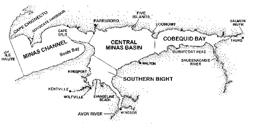
Central Minas Basin, Southern Bight and Cobequid Bay together, form an obtuse triangle about 80 kilometres long and 29 kilometres wide at its broad western end. It narrows to a point in the estuary of the Salmon River near Truro, at the head of Cobequid Bay. The Micmac name "Cobequid" aptly signifies "the end of flowing waters". The western border of Cobequid Bay falls on a line between Economy Point to the north and Burntcoat Head to the south. The division between the Southern Bight and central Minas Basin is not as well defined, running roughly from the midpoint of Cape Blomidon to Red Head. The depth over much of Minas Basin is less than 25 metres at low tide (average 14.5 metres), although the deeper Minas Channel trough intrudes in from the west. The area of the Basin, including its various estuaries, is about 115,000 hectares. The very high tidal amplitude causes the surface area of the water in the Basin to shrink markedly as the tide ebbs. The waterline may recede as much as 5 kilometres seaward, exposing an intertidal zone of almost 40,000 hectares, more than a third of the Basin’s total area. Biologist Ed Bousfield noted that "No other coastal marine area in the world of comparable size has such a large proportion of bottom exposed to the air environment at low tide".
More than half the area of the upper reaches of the Bay of Fundy consists of intertidal mud or sand flats. The Triassic sandstone cliffs surrounding Minas give its coastal flats a higher sand and lower silt content than those in neighbouring Chignecto Bay, where the cliffs are mostly siltstone and shale. In the Minas region, fine silt and clay deposits occur in sheltered embayments where mudflats and salt marshes have formed. The area of the tidal flats in Minas Basin is about 35,800 hectares; almost half of it in Cobequid Bay and the rest equally divided between central Minas Basin and the Southern Bight. Minas Basin also contains about 1,330 hectares of low salt marsh, almost 80% of which is concentrated around the Southern Bight, that is regularly flooded by the tide. Much of the Basin’s original high marsh has long been dyked and drained for agricultural use. The combined area of the Minas Basin and Channel is about 190,000 hectares. The watershed, or surrounding land area that drains into and thus influences this marine ecosystem, is nearly five times larger, almost 900,000 hectares, encompassing over 20 percent of mainland Nova Scotia.
Reading the Rocks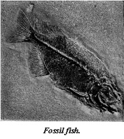
The Minas Channel shores are rocky and steep and similar to those of the Bay of Fundy to the west. Its intertidal zone is small, encompassing scarcely more than 1,300 hectares along its length. Gently curving embayments - Advocate Bay, Greville Bay and West Bay on the northern shore, and Scots Bay to the south - have shelving beaches of firmly packed sand and mud, with coarse gravel and boulder fringes at the high water line. The shores surrounding the Basin itself are quite different, except at the western end, where the high basaltic cliffs of Cape Blomidon mark the end of the North Mountain range that delineates the Nova Scotian coast of the Bay of Fundy. The shores eastward around the southern Bight and Cobequid Bay consist mostly of low cliffs of easily erodible soft sandstone, shale and glacial till (deposit of rocks and finely ground material left by glaciers). At Avonport, Grand Pr�, and Hortonville, "drumlins", low elongated mounds of rocks and clay, shaped like half an egg and formed during the passage of heavy ice sheets, attest to the presence of glaciers more than 12,000 years ago. The Triassic sandstones contain an iron-rich binding material (haematite) that gives them their characteristic deep red colour. This oxidises and crumbles on exposure to air, allowing the coast to erode rapidly. The released sand and silt wash onto the tidal flats to form wide beaches, mudflats and broad salt marshes cut by deep river channels. The northern shore of the Basin consists of a discontinuous chain of high, basalt bluffs and rocky islands, fronted by broad tidal flats.
The shores of the Basin yield a rich trove of semi precious
minerals and fossils. "Rockhounds" scour the beaches near Parrsboro and Scots
Bay for jasper, chalcedony,amethyst, several varieties of agate and different types of
zeolites. The fossil diversity around the Basin is even more remarkable, and now
internationally recognised. Embedded in the sandstones and shales are the remnants of past
ecosystems, such as lush Carboniferous tree-fern forests, ancient seafloors and luxuriant
tropical lagoons. Researchers have discovered fossilised plant fragments, fish scales and
fin spines, worm burrows, arthropod trails, amphibian bones, and the tell-tale marks of
ancient raindrops and ripples. Footprints, which proved to be the largest amphibian tracks
ever seen in such ancient rocks, were found near the mouth of the Avon River. The
Kennetcook River is noted for its marine fossils, including horn corals, stony bryozoa,
brachiopods, pelecypods, cephalopods and trilobites. The north shore of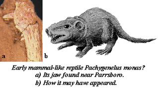 the Basin is also known for its varied fossilised plants, animals and
amphibian trackways. However, it is unquestionably the fossils of dinosaurs and their
tracks that have attracted most attention. The rocks of Cape Blomidon have yielded the
tracks of a pheasant-sized, bird-hipped dinosaur, Atrepius, one of the oldest found
in Canada. Prosoraupods and other dinosaur fossils and tracks are found in the sandstone
along the Parrsboro shore. Nearby Wasson’s Bluff became known worldwide in 1986 with
the discovery of an unusual mammal-like reptile, Pachygenelus. Two hundred million
years ago, at what geologists term the "Triassic-Jurassic Boundary", half the
species on Earth died off, including all the dinosaurs. The cause of this catastrophe is
still being debated, although most scientists now believe that a large meteorite slammed
into the Earth and drastically altered its climate. This extinction event is well
documented in the fossils found in the rocks along the north shore of the Minas Basin.
Because of their immense scientific value, all such fossils found in bedrock are protected
by law and some areas are off limits to amateur fossil collecting. This rich and still
unfolding fossil history of the upper Bay of Fundy is preserved, documented and made
accessible to researchers and the public at the popular Fundy Geological Museum in
Parrsboro.
the Basin is also known for its varied fossilised plants, animals and
amphibian trackways. However, it is unquestionably the fossils of dinosaurs and their
tracks that have attracted most attention. The rocks of Cape Blomidon have yielded the
tracks of a pheasant-sized, bird-hipped dinosaur, Atrepius, one of the oldest found
in Canada. Prosoraupods and other dinosaur fossils and tracks are found in the sandstone
along the Parrsboro shore. Nearby Wasson’s Bluff became known worldwide in 1986 with
the discovery of an unusual mammal-like reptile, Pachygenelus. Two hundred million
years ago, at what geologists term the "Triassic-Jurassic Boundary", half the
species on Earth died off, including all the dinosaurs. The cause of this catastrophe is
still being debated, although most scientists now believe that a large meteorite slammed
into the Earth and drastically altered its climate. This extinction event is well
documented in the fossils found in the rocks along the north shore of the Minas Basin.
Because of their immense scientific value, all such fossils found in bedrock are protected
by law and some areas are off limits to amateur fossil collecting. This rich and still
unfolding fossil history of the upper Bay of Fundy is preserved, documented and made
accessible to researchers and the public at the popular Fundy Geological Museum in
Parrsboro.
Less ancient fossil artifacts found on the mudflats around the Southern Bight, lack the cachet of the dinosaurs, but add another important, later chapter to the region’s history. The shattered trunks of a 4,400-year-old forest protrude incongruously from the mud near Evangeline Beach. Not far away, layers of buried shells mark the location of 3,800 year old beds of oyster and soft-shell clams. The ancient burrows of boring clams pockmark some of the surrounding rocks. Biologist Sherman Bleakney, of Acadia University, who found many of these remains, has used them to construct a picture of the Basin 4,000 years ago that is very different from what we see there today. Then, the global sea level was much lower and the Basin a largely tideless lagoon of clear, brackish water almost completely cut off from the sea — not unlike Glooscap’s legendary beaver pond.
Faulty Flush?Today, the Basin’s oceanography is dominated by tides that exceed those of any other location in the world. They are even 1.5 metres higher than in nearby Chignecto Bay, because the "Coriolis Force", produced by the rotation of the Earth, nudges the tidal bulge towards the southeastern side of the Bay of Fundy. The average tidal range is an impressive 13 metres, while spring tides up to 16 metres are common. The world record tidal amplitude of 16.27 metres occurs at Burntcoat Head, on the southern shore of the Basin. During the notorious "Saxby Gale" of 1869, a deadly combination of high tide, gale force winds and low atmospheric pressure lifted the sea at the head of the Basin to a remarkable 21.6 metres, causing massive flooding and devastation.
The large tidal amplitude causes more than 10 cubic kilometres of seawater, weighing 10 billion tonnes, to flow into and out of the Basin twice daily, more than forty times the flow of the St. Lawrence River. As the Basin fills, the weight of water causes the surrounding land to dip slightly under the load. The water squeezes through the 5 kilometre wide gap at Cape Split, a bottleneck that causes the incoming water to pile up in Scots Bay, producing a noticeable difference in the height of the sea surface. The inrushing flow reaches speeds of 4 metres per second (8 knots), swirling past Cape Split in a maelstrom of turbulent currents and gyres. Once past this constriction, the water spreads out inside the Basin and slows considerably.
One would expect, with this frequent surge of water, that the Basin would be well "flushed" and that anything dumped in it would be dispersed rapidly throughout the Bay of Fundy. However, some of the same water may simply slosh in and out of the Basin over a number of tidal cycles. The effect of this can be seen in the Minas Channel, where local fishermen talk about the curiously named "cedar swamp". Much of the water in this deep channel seems to move outward on the falling tide and back inward on the rising tide. This isn’t noticeable in the water itself, but is clearly evident in the debris floating in it. Anything that drifts into the area, seaweed, garbage, driftwood or wreckage, gets trapped in an eddy that has been likened to a miniature "Sargasso Sea". This debris moves back and forth in an area between Cape Split and Ile Haute. The wreck of one small boat drifted there for months before it finally waterlogged and sank. Fishermen, who once made their fishing floats out of cedar, conferred the name on the area. Floats lost in storms could invariably be retrieved in large numbers from the "cedar swamp". This oceanographic phenomenon may have important ecological implications. Wastes dumped into the Basin may not be flushed out as quickly as one might expect. It may also be critical for some marine species with "planktonic" larval stages that occur in the Basin but not in the Bay of Fundy. Sufficient larvae may be kept in the Basin long enough to settle to the bottom and maintain the population.
Tilting Against TurbidityThe swirling water is well mixed from top to bottom, so there is little chance for it to "stratify", or form layers of different temperatures or salinities. The Basin’s water is warmer in summer and colder in winter than in the main part of the Bay of Fundy. In late summer it may reach 14�C in the Minas Channel and central Basin and 21�C in upper Cobequid Bay. On hot, calm days, the shallow water flowing over the sun-baked intertidal mudflats may reach 26�C. In midwinter, the water temperature hovers around the freezing point. The salinity ranges from about 31 parts per thousand in the Channel to 28 parts per thousand in upper Cobequid Bay. The water can be even more brackish within the estuaries of the larger rivers.
The wearing away of the soft, red rocks around the basin provides a steady supply of fine silt and sand that is kept suspended in the swirling seawater. These particles sharply limit the penetration of light into the water. Oceanographers traditionally measure this murkiness, or "turbidity", of the water with a "Secchi disk". This is a simple plastic disk, several inches in diameter, with black and white segments painted on its upper surface. It is lowered into the water on a measured cord and the depth at which it just disappears is noted - the less the "Secchi depth", the more turbid the water. In the Bay of Fundy the disk disappears at six to ten metres, while in the Minas Channel it is invisible after three or four metres. In the central Minas Basin the Secchi depth varies with the tide, from about two metres at mid-tide to four metres at slack water. Closer to shore in the Southern Bight, the disk disappears in just a few centimetres - some biologists working with their hands wrist-deep in the water couldn’t see their finger tips.
With its extreme tides, turbulent currents, soft substrates and silt-laden waters, Minas Basin is a stressful environment. Many marine species simply can’t cope. However, for those that can, there is little competition and their populations flourish. There are a relatively small number of different species compared to many marine areas, but a few of those species have extremely large populations, a situation that biologists term "low biodiversity". Marine plant production in the Basin is lower than in most estuaries because of the extreme turbulence and turbidity. Light can’t penetrate far into the sediment-laden waters, limiting phytoplankton growth. Seaweeds can’t attach to the shifting, muddy substrate or get enough light in the murky waters. However, the mudflats are fringed by salt marshes, from which fragments of dead marsh grass, or "detritus", wash into the sea with each tide. Also, the vast stretches of intertidal mudflats exposed to the warm sun provide an ideal surface for the growth of "benthic diatoms", microscopic plants that form lush green or brown mats. Half of the primary (plant) production comes from these mudflat diatoms, with the remainder almost equally split between the phytoplankton and salt marshes.
Over a hundred species of zooplankton have been found in Minas Basin. Contrary to expectations, zooplankton production is nearly as high as in other less turbid waters. There are fewer herbivorous zooplankton dependent on phytoplankton, but more omnivorous species that eat detritus or the bacterial film on silt particles. The abundance and distribution of zooplankton is patchy and constantly changes during the course of a tidal cycle. The assemblage in the Southern Bight is dominated by small estuarine copepods. Detritus-eating Mysid shrimp, hovering in swarms above the muddy bottom, are an important food for shad, alewives and other fish.
It was once assumed that the soft, sticky mudflats were relatively lifeless. We now know that they teem with subterranean life. A few types of invertebrates dominate, each doing best in areas where the mixture of sand and silt has a consistency particularly to its liking. The burrowing amphipod Corophium volutator crowds the mudflats of the Southern Bight, with up to 60,000 rice-sized animals per square metre. The clam Macoma baltica is more abundant in southern Cobequid Bay than anywhere else in the upper Bay of Fundy. The larger soft-shell clam, Mya arenaria, is most abundant along the northern coast of the Basin. Several species of burrowing polychaete worms are numerous in some areas. Common rock barnacles are abundant where there are rocky outcroppings, as are the whelks that prey on them. Mud snails, Ilyanassa obsoleta, are numerous and conspicuous on many mudflats. Most of these bottom-dwelling animals are detritus feeders, scavengers or predators. Animals that filter phytoplankton and suspended organic matter from the water, such as blue mussels and oysters, are conspicuously absent, presumably because the turbid water would quickly clog their filters. Echinoderms, such as starfish and sea urchins, which prefer clearer water, are also scarce.
Interestingly, there are some animals that live and breed in the Basin in seeming isolation. These include species of jellyfish, crabs, barnacles, planktonic copepods, snails and bivalve molluscs. The nearest populations are in the southern Gulf of Maine or the warm, brackish water of the southern Gulf of St. Lawrence. Those in the Basin may be hangers-on, or "relicts", of a period some 4,000 years ago when the climate was warmer and their populations extended over the whole region. With declining temperatures, isolated groups of these species were trapped in a few favoured pockets, or "refugia", that had water slightly warmer than the rest of the region.
Failing Fisheries?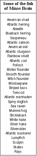
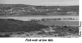
The Minas Basin is home to a variety of fish, some of which were once exceptionally abundant. At least 50 species have been found in the region. The channels winding through the salt marshes are important nursery areas for some of them. For generations, the fisheries sustained many coastal communities, but over many decades the stocks of most commercial fish have declined and the fisheries have dwindled. The high tidal range was ideally suited to the weir fishery, which for generations was the most popular harvest method. The crescent-shaped weirs, constructed of brush or twine netting suspended on stakes driven into the mudflats, were ingeniously designed and positioned to trap fish on the receding tide. They indiscriminately caught a wide range of commercial and non-commercial fish as well as the occasional shark, porpoise or tuna. An observer in the 1850s reported that there was, on average, one weir every mile along the north shore of the Basin. In particularly favourable areas there was an almost unbroken line of weirs, with ends almost touching. Now, only a handful of them are seen.
 The American shad was
once the dominant fishery in the Basin. Prior to 1900, thousands of barrels of salt shad
were exported each year. Weir catches ranged as high as 100,000 fish on a single tide.
However, by 1910 shad numbers had fallen sharply, probably because of new hydro dams on,
and pollution of, many New England spawning rivers. Nowadays, a catch of more than a
thousand fish is exceptional. The second most important fishery was for the Atlantic
salmon that crowded into the many rivers surrounding the Basin to spawn. These were also
caught with weirs, as well as with fixed or floating gill nets. The largest numbers were
caught in the Avon and Economy rivers and in Cobequid Bay. By the 1950s, salmon numbers
had also fallen sharply, a decline that has continued to the present day. Commercial and
recreational salmon fisheries are now banned and there are calls for the surviving fish to
be declared an endangered species.
The American shad was
once the dominant fishery in the Basin. Prior to 1900, thousands of barrels of salt shad
were exported each year. Weir catches ranged as high as 100,000 fish on a single tide.
However, by 1910 shad numbers had fallen sharply, probably because of new hydro dams on,
and pollution of, many New England spawning rivers. Nowadays, a catch of more than a
thousand fish is exceptional. The second most important fishery was for the Atlantic
salmon that crowded into the many rivers surrounding the Basin to spawn. These were also
caught with weirs, as well as with fixed or floating gill nets. The largest numbers were
caught in the Avon and Economy rivers and in Cobequid Bay. By the 1950s, salmon numbers
had also fallen sharply, a decline that has continued to the present day. Commercial and
recreational salmon fisheries are now banned and there are calls for the surviving fish to
be declared an endangered species.
Local trawlers fished for winter flounder in the Basin for many years. The vessels’ small size and low horsepower prevented them fishing at all stages of the tide and thus limited their catches. This imposed a natural control on harvesting and ensured a sustainable fishery. However, in the late 1980s, larger trawlers from the lower Bay, having fished out flounder stocks there, moved into Minas Basin. These could work continuously at all stages of the tide, day and night and with much larger, heavier trawls. Within a very short time they decimated the flounder stock and numbers have never fully recovered, leaving a much-reduced fishery. The fifteen or so local vessels still operating in the Basin now harvest a mix of species, such as groundfish and lobster in different seasons. The lobsters are concentrated in the deeper areas of the Minas Channel, where strong currents sweep the gravelly bottom free of silt. Only very large, heavy traps weighed down with hundreds of pounds of concrete can be set in such currents, requiring the use of larger boats than are normally used for lobstering.
The digging and processing of the soft-shell clam has also been
a lucrative fishery in the Basin over the years. It is also one of the least
capital-intensive, requiring only an "hack" (a long-tined rake for turning over
the sediments), buckets and a cart for transporting the paraphernalia and catch over the
tidal flats. Commercial clamming began early in the 1940s, with a peak production of 946
tonnes in 1946. Over the next two decades, production declined as the existing large clams
were depleted. A rise in abundance, accompanied by an increasing demand and climbing
prices led to a resurgence in production in the 1970s. By the early 1980s, Minas Basin
accounted for almost a third of Nova Scotia’s clam production. In 1982, one hundred
and ten full-time, licensed clammers, many part-timers and three processing plants
produced over 680 tonnes of clams, worth at least half a million dollars. It has been
estimated that only about one and half percent of the Basin’s extensive tidal flats,
or about 445 hectares, have the ideal mix of sand and mud for prime clam habitat. The most
productive clam flats are located along the northern shore of the Basin, particularly
between Five Islands and Bass River. In recent decades, production has once again
declined, with fewer, smaller clams present, some of the flats closed because of sewage
contamination, and a reduced number of clammers.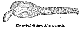
The mudflats of the Southern Bight have a finer consistency and are better suited to a variety of burrowing polychaete worms. Some of these, particularly the bloodworm, Glycera dibrachiata, are the target of a commercial baitworm harvest. Large quantities are dug and exported to the northeastern states for use as live bait in recreational fisheries. This harvest expanded rapidly in the Minas Basin in the mid 1980s, after overexploitation had decimated the worm populations around the Gulf of Maine and outer Bay of Fundy. Harvesters manually turn over the mud with a hack, disturbing large swaths of mudflat on each low tide. There are concerns that this may be harming the Corophium that share the mudflats and are critical food for migrating shorebirds. There is little reliable information about production rates and sustainable harvest levels for the worms, making it difficult to develop meaningful, long-term management policies to protect the population from overexploitation.
Wildlife and Waterfowl
It is unlikely that Minas Basin will ever become a hotbed for whale watching comparable to that at the mouth of Fundy. However, small pods of harbour porpoises are sometimes seen and common and Atlantic white-sided dolphins are periodic summer visitors. Larger whales, such as pilot, minke and humpback, are rare but do occasionally strand on the mudflats. While not overly attractive to marine mammals, the Basin is a magnet for waterfowl and shorebirds that congregate in huge flocks at particular times of the year. The shallows of the Southern Bight and Cobequid Bay are important wintering areas for black ducks, loons and mergansers. The wetlands and marshes around the Basin are foraging areas for dabbling ducks and geese during spring and fall migrations. Further offshore, common eiders, oldsquaws and white-winged scoters wait out the winter months. Boot Island, off the mouth of the Gaspereau River, and Egg Island, one of the Five Islands, are nesting sites for double-crested cormorants, herring gulls, great black-backed gulls and great blue herons. Peregrine falcons once nested on cliffs around the Basin, with the last known aerie on the 60-foot rock face of Diamond Island, another of the Five Islands. In the past decade, captive breeding programs have re-established these swift, graceful predators in some places in the upper Bay. However, it is for its shorebirds, particularly the long-legged sandpipers and plovers, that the Basin is world renowned among birders and conservationists. The critical importance of the mudflats as foraging areas for millions of migrating sandpipers is described in Fundy Issues Number 3, "Sandpipers and Sediments: Shorebirds in the Bay of Fundy". These mudflats are so important to the survival of the sandpipers that 26,800 hectares of the coast of the Southern Bight, north of Wolfville, has been designated a RAMSAR site (don’t bother guessing! It’s not an acronym, but a small city in Iran where the convention was signed), a wetland of international significance. This area is also part of the Western Hemisphere Shorebird Reserve network that protects the chain of habitats of migrating shorebirds stretching from the Arctic to southern South America. Other Opportunities
With the highest tides in the world, and its semi-enclosed, basin-like form, it is not surprising that the Minas Basin has long attracted engineers to the challenge of converting this massive, ceaseless flow of water into electricity. On average, eight cubic kilometres of seawater surges past Cape Split on each tide, with a power roughly comparable to that 25 million horses. As long ago as 1915, Ralph Clarkson, a physics professor at Acadia University, built a prototype tidal power generator that he planned to set up near Cape Split. He even recruited investors in the Cape Split Development Corporation. But the project ended abruptly in 1920, when the device was destroyed by fire. Other proposals have surfaced periodically over the intervening years. In the 1950s and 60s, the Atlantic Tidal Power Programming Board considered proposals for tidal power projects in many places in the Bay of Fundy, including the Minas Basin. By the 70s, attention had narrowed to a small number of sites, particularly a barrage across Cobequid Bay from Economy Point to Cape Tenny. This stimulated a flurry of engineering and ecological research in the late 70s and early 80s. To help resolve some of the difficult technological and environmental questions, a small prototype tidal power plant was built on the Annapolis River in 1986. Since then, there has been little overt activity in relation to Fundy tidal power. The engineers have not lost interest, but are simply awaiting a more favourable economic climate.
Minas Basin also offers an impressive range of opportunities for
visitors interested in the outdoors and natural history. Provincial Parks at Cape
Blomidon, Five Islands and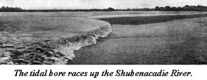 Cape
Chignecto offer first class camping, coastal hiking and marine scenery. The rugged trail
out to Cape Split has long been a magnet for hikers, and a newly constructed one around
Cape Chignecto draws rave reviews and a growing stream of visitors. There are also
opportunities for those more interested in aquatic pursuits. Riding the two-metre crest of
the tidal bore, at 13 kilometres an hour, for several kilometres up the Shubenacadie River
in an inflatable boat is a unique experience that thrills tourists from around the world.
Sea kayaking is an increasingly popular way to explore the Basin’s coastline,
although the tidal currents and rips in the region make it an adventure best enjoyed in
the company of experienced local guides. The rivers flowing into the Basin have long
provided sport for anglers seeking trout, striped bass and salmon. Regrettably, salmon
populations are so depleted that the fishery has been closed for a decade. Ice fishing for
rainbow smelt, perch or tomcod has long been a popular pastime in some estuaries.
Rockhounds and fossil seekers are drawn to the unique rock formations of the region and
find the Fundy Geological Museum a trove of useful information. Naturalists flock to the
area to experience its wild beauty and rich biodiversity. Birdwatchers in particular, find
the area’s abundant waterfowl and shorebirds endlessly fascinating. Evangeline Beach,
for example, is world famous for the awesome summertime aerial ballets by flocks of tens
of thousands semipalmated sandpipers. The many natural features around the Southern Bight
have been well documented by the Blomidon Natural History Society in "The Natural
History of Kings County". The budding ecotourism industry clearly has much scope for
growth and diversification in the region.
Cape
Chignecto offer first class camping, coastal hiking and marine scenery. The rugged trail
out to Cape Split has long been a magnet for hikers, and a newly constructed one around
Cape Chignecto draws rave reviews and a growing stream of visitors. There are also
opportunities for those more interested in aquatic pursuits. Riding the two-metre crest of
the tidal bore, at 13 kilometres an hour, for several kilometres up the Shubenacadie River
in an inflatable boat is a unique experience that thrills tourists from around the world.
Sea kayaking is an increasingly popular way to explore the Basin’s coastline,
although the tidal currents and rips in the region make it an adventure best enjoyed in
the company of experienced local guides. The rivers flowing into the Basin have long
provided sport for anglers seeking trout, striped bass and salmon. Regrettably, salmon
populations are so depleted that the fishery has been closed for a decade. Ice fishing for
rainbow smelt, perch or tomcod has long been a popular pastime in some estuaries.
Rockhounds and fossil seekers are drawn to the unique rock formations of the region and
find the Fundy Geological Museum a trove of useful information. Naturalists flock to the
area to experience its wild beauty and rich biodiversity. Birdwatchers in particular, find
the area’s abundant waterfowl and shorebirds endlessly fascinating. Evangeline Beach,
for example, is world famous for the awesome summertime aerial ballets by flocks of tens
of thousands semipalmated sandpipers. The many natural features around the Southern Bight
have been well documented by the Blomidon Natural History Society in "The Natural
History of Kings County". The budding ecotourism industry clearly has much scope for
growth and diversification in the region.
Mining in the area has largely been land-based, most notably the extraction of gypsum and gold in the Rawdon Hills east of Windsor. However, there is growing interest in the non-renewable mineral resources of the Basin itself. Geological mapping suggests that there could be worthwhile hydrocarbon reserves beneath Cobequid Bay. The area’s thick, well-sorted deposits of clean sand could also be of great interest to the cement-mix and glass making industries. The Atlantic Geosciences Centre has surveyed other large deposits of clean sand and well-sorted gravel in the Scots Bay portion of the Minas Channel in recent years. A mining company recently obtained leases in Cobequid Bay and is now seeking regulatory approval for exploratory surveys for titanium and other rare metals in the sediments along the southern Shore and in the lower reaches of the Shubenacadie River.
Issues and ImpedimentsClearly, Minas Basin and its watershed are blessed with many natural resources that can be sustainably used for the benefit of its communities far into the future. However, as we have seen, some of these resources, notably the fisheries, have long been abused and need much co-operative effort if they are ever to be rejuvenated. Biodiversity, habitats and ecological processes are also threatened by some present or anticipated activities in the Basin and its watershed. Many other economic opportunities based on the region’s natural resources languish unrealised. If the communities of the region are to harmonise their social, ecological and economic aspirations and fulfil the area’s potential, they must deal with a number of pressing issues. The implications of climate change, global warming and rising sea level have to be carefully examined. Increasing coastal erosion, destruction of dykes by storm surges, flooding of coastal communities, and changes in the distribution of plants and animals are just a few of the worrisome problems that have already been identified.
Depletion of fish and shellfish stocks and the destruction of marine habitats by inappropriate or unregulated harvesting, threaten the resources and the biodiversity in the region. Tidal barriers or restrictions on the Avon, Gaspereau and St. Croix rivers, and under-sized culverts and bridge abutments on other waterways, impede tidal exchange. These structures can adversely affect not just the rivers and their estuaries, but areas far out into the Basin. There is a need for more conservation and recreation areas around the Basin to protect wildlife and habitats, as well as to cater to the growing ecotourism industry. The infrastructure needed to encourage ecotourism is poorly developed in many parts of the region. For example, the main road along the Basin’s north shore is in such disrepair that it undoubtedly deters many potential visitors to the new Cape Chignecto Provincial Park.
It is only a matter of time before interest in tidal power development revives, and its profound social, economic and ecological consequences will have to be examined. Careful consideration must also be given to the proposals to extract non-renewable resources from marine areas, to determine if this can be carried out in an ecologically benign manner. There is a need for a detailed examination of the way that sewage and other wastes are being dealt with throughout the region, particularly in the larger urban centres. Should dykeland that is no longer being used for agricultural production be allowed to revert to its original salt marsh habitat, converted to freshwater marshes attractive to waterfowl or used for commercial or residential construction? The list of problems and unresolved questions pertaining to the future of Minas Basin is lengthy. But, they have to be addressed soon if the communities that hug its shores are to grow and prosper in a sustainable manner.
Partnerships for Progress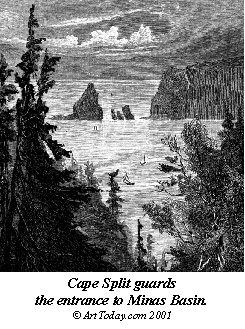
Many groups are seeking ways to resolve the issues that are impeding progress in the region. They realise that difficulties will only be resolved, and sound decisions made, if everyone works together in a spirit of co-operation. Concerned citizens, communities, interest groups, governments at all levels, and industry have to be actively involved in the process. The following are a few examples of ongoing efforts to promote co-operation and encourage sustainable resource use throughout the Basin and its watershed.
The Bay of Fundy Ecosystem Partnership (BoFEP), through its Minas Basin Working Group, recently embarked on a project aimed at protecting biodiversity and enhancing environmental quality in the region, while fostering sustainable use of natural resources by existing and future generations. It hopes to do this by working with communities and other interested groups to develop a broadly supported management plan for the region. An important early step is to involve the residents and groups in the area, through meetings and workshops, in identifying the natural resources that they value, the threats to those resources and the environmental issues that they consider most pressing. BoFEP can play a useful role in finding and disseminating the scientific information about the region that might be needed to make sound decisions. It can also help in bringing together and encouraging co-operative activities among the groups and individuals that need to be involved in the process. BoFEP is also well placed to encourage and facilitate participation by its scientific partners, and others, in carrying out research when information is lacking. It might also have an important role to play in seeking funding opportunities for such research and conservation projects. An initial project to prepare a database of groups and agencies with an interest in Minas Basin has recently been completed. A preliminary listing of issues relevant to the Basin and its watershed has also been prepared as a basis for discussion by communities. In addition, a database of available scientific and other information about the Basin and its environs has been set up. Efforts are also being made to co-ordinate the activities of BoFEP and its partners with complementary efforts by several other groups in the region.
One novel concept is to propose that the Minas Basin region be designated an internationally recognised "Biosphere Reserve". This designation is given by the United Nations Educational, Scientific and Cultural Organisation (UNESCO) to selected regions where there is an undertaking to promote and demonstrate a balanced relationship between humans and nature. A Biosphere Reserve would help to conserve biodiversity in the region, foster economic development in a sustainable manner and catalyse logistic and other support for a range of conservation and development activities. A key requirement of the Biosphere Reserve concept is that it must be supported and managed by those living in the region. It is a mechanism to help people find a suitable balance between long-term economic development and environmental conservation that they can accept and are prepared to live with. It encourages communities to seek out new and innovative ways of integrating economics and ecology and to share their success stories with the world. The initial proposal for such a Biosphere Reserve in the Fundy region came from the Bay of Fundy Product Club, an umbrella organisation of tourism groups from both Nova Scotia and New Brunswick. This group was initially interested in the potential of a Biosphere Reserve for attracting tourists to the region. However, it soon became apparent that it has much broader social, economic and environmental implications than just tourism. The Bay of Fundy Ecosystem Partnership, through its Working Groups, has assisted in the process by providing a venue for exploring some of these other perspectives, particularly from the science and conservation viewpoints. The Biosphere Reserve proposal also complements other community outreach initiatives that BoFEP is undertaking in the region. The Minas Basin and its environs could be an excellent location for launching a "pilot project" Biosphere Reserve that could, if desired, be expanded later to encompass more of the Bay of Fundy. Nearby Chignecto Bay is another possible site for such a pilot project. However, before any such project proceeds there will have to be broad, in-depth consultations with all the communities, agencies and groups that will be affected.
The Bay of Fundy Fisheries Council, an umbrella organisation of fishermen’s groups from all around the Bay, is engaged with various partners, including BoFEP, to promote the development of an integrated fisheries management regime in Minas Basin and elsewhere in the upper Bay. It hopes to do this by building on the momentum of its "Writing the Rules" Project, which explored ways of promoting community-based management of ecologically sustainable fisheries in the Bay of Fundy. Although primarily directed towards resource harvesters, this initiative complements the Biosphere Reserve proposal and BoFEP’s Minas Basin Project.
The people living in communities around the Basin are gradually coming to realise that this "ecological jewel" in their midst is not glittering as brightly as it could, and indeed is at risk of becoming even more tarnished and blemished. They also recognise that by working together, the potential of the Basin can be enhanced, allowing both present and future generations to use its resources, treasure its diversity, delight in its stark beauty and enjoy the many pluses of Minas.
Further Reading
Harry Thurston. Camden House Publishing, Camden East, Ontario. 167 pages. (1990).Tidal Life: A Natural History of the Bay of Fundy.
The Fauna of Minas Basin and Minas Channel.
E.L. Bousfield and A.H. Leim. Contributions to Zoology, 1958. Canada Department of Northern Affairs and National Resources. National Museum of Canada, Bulletin Number 166. 29 pages. (1959).Intertidal Invertebrates of Scots Bay and Western Minas Basin, Nova Scotia.
Edward Paul McCurdy M.Sc. Thesis, Acadia University, Wolfville, N.S. 74 pages. (1979).Update on the Marine Environmental Consequences of Tidal Power Development in the Upper Reaches of the Bay of Fundy.
Edited by D.C. Gordon, Jr. and M.J. Dadswell. Canadian Technical Report of Fisheries and Aquatic Sciences, Number 1256. 686 pages. (June 1984).The Natural History of Kings County.
Revised Edition. The Blomidon Naturalists Society, Acadia University, Wolfville, N.S. 196 pages. (1993).Effects of Baitworm Harvesting on the Prey and Feeding Behaviour of Shorebirds in the Minas Basin Hemispheric Shorebird Reserve.
Philippa C. F. Shepherd. M.Sc. Thesis, Acadia University, Wolfville, N.S. 95 pages. (1994).The Postglacial Evolution of the Minas Basin, N.S.: A Sedimentological Interpretation.
C.L. Amos. Journal of Sedimentary Petrology, Volume 48, pages 965 to 982. (1987).This fact sheet may be reproduced and circulated, with credit to the
Bay of Fundy Ecosystem Partnership The Fundy Issues series is financially supported by:
The Environmental Conservation Branch
Environment Canada - Atlantic Region
Dartmouth, Nova Scotia
and
Department of Fisheries and Oceans
Scotia-Fundy Region
The views expressed herein are not necessarily those of the supporting agencies.
Written and produced by
J.A. Percy,
Sea Pen Communications
Granville Ferry. N.S.
e-mail: bofep@auracom.com