Ecology Action Centre
Salt Marsh Restoration Project Report
[Submitted by Tony Bowron, EAC, July 2003]
Protecting, restoring and raising awareness about the beauty and significance of Nova Scotia’s coastal wetlands is the focus of the Ecology Action Centre’s (EAC) Salt Marsh Restoration Project.
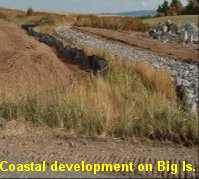
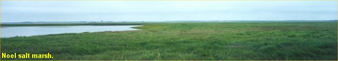
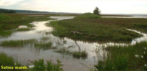
Salt marshes are coastal wetlands that act as a transition zone between the land and the sea. Healthy salt marshes provide habitat for birds, fish, and other wildlife. Salt marshes contribute significantly to the overall productivity of the Bay of Fundy. Over 80% of the original salt marshes in the Bay of Fundy have been lost or several degraded through human activity, such as dyking, ditching, road construction, coastal development, and in-filling. Railways, highways, and roads often act as obstructions or barriers that have considerable impacts on water flow (hydrology) of estuaries, rivers, and coastal wetlands. Tidal barriers are structures that prevent the natural movement of tidal waters into low-lying coastal areas. The most common types of tidal barriers are causeways with culverts that are either too small or not properly located within the waterway to allow for the natural movement of water and species.
The EAC’s Salt Marsh and Tidal Rivers Restoration Project
The Minas Basin is the southern branch of the Upper Bay of Fundy; it is a bounded by Kings, Hants, Cumberland, and Colchester Counties. It is a semi-enclosed body of water with extreme tides and extensive mudflats.
To address the cumulative loss of salt marsh habitat in the Minas Basin, the EAC has a number of ongoing activities in the area. Public education, community outreach, school programs, data collection, fieldwork, and collaborative restoration planning are part of our efforts to protect and restore salt marshes and tidal rivers in the Minas Basin.
 Tidal
Barriers Audit
Tidal
Barriers Audit
A Tidal Barriers Audit is an important first step in
the restoration process. It is done to assess whether the natural daily tidal
flow to rivers and salt marshes is blocked or restricted. The purpose of the
tidal audit is to identify sites that have been negatively impacted by a
restrictive tidal crossing. In such sites, removing the tidal restriction can
restore the marsh’s natural functions, improve habitat, and restore fish
passage.
The EAC has completed two tidal audits in the Minas Basin. The first, during the summer of 2001, focused on coastal Hants County, from Maitland to Cheverie. Twenty-one tidal crossings were found. Of these, nine were partially restricted and five were completely restricted. In 2002, in partnership with the Municipality of Colchester County, a tidal audit was completed for the entire coastal portion of Colchester County. Of the 54 tidal crossings in Colchester County, 29 were completely or partially restricted. In 2003, the tidal barriers project will expand into Cumberland County through to the New Brunswick boarder and from Cheverie, in West Hants, to Blomidon, in Kings County.
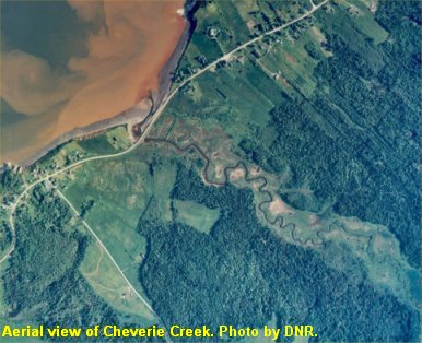
Cheverie Creek Restoration Site
 Cheverie
Creek is a small-sized tidal river located in Cheverie, West Hants County. Salt
water does not regularly flood the entire marsh because the culvert in the
causeway that crosses Cheverie Creek is too small and partially restricts tidal
flow. The culvert is also damaged at both ends and partially blocked by rocks
and other roadway material, further restricting the tidal flow.
Cheverie
Creek is a small-sized tidal river located in Cheverie, West Hants County. Salt
water does not regularly flood the entire marsh because the culvert in the
causeway that crosses Cheverie Creek is too small and partially restricts tidal
flow. The culvert is also damaged at both ends and partially blocked by rocks
and other roadway material, further restricting the tidal flow.
In the summer of 2002, field research was conducted at Cheverie Creek to collect baseline data about the marsh and to explore the potential for successful restoration through culvert replacement. Most of the information collected to date has been through vegetation surveys and Global Positioning System (GPS) mapping. Preliminary fish and bird counts, salinity testing, and sediment movement analysis was also done. Plans for the summer of 2003 include: further hydrological modeling and monitoring; complete GPS mapping; further fish, bird, salinity, and temperature surveys; expansion of the community outreach program; and collaboration with project partners such as the Department of Transportation and Public Works to design and plan for the replacement of the culvert at Cheverie Creek.
Other Sites of Interest
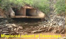
The Tennecape River is a large river completely restricted by a causeway and misplaced culvert. We plan to begin community discussions and preliminary baseline data collection at this site during the summer of 2003. There are also monitoring activities planned for Mill Brook, near Cheverie and at a site along the Cogmagun River in Center Burlington.
For more information about salt marshes or the EAC’s Salt Marsh Restoration Project, please contact the Salt Marsh and Tidal Rivers Restorations Project, at 429-2202 or coastal@ecologyaction.ca
Photos by T. Bowron. Aerial Photo of Cheverie Creek by the Department of Natural Resources.